Thursday, November 30, 2006

Hyde Park Corner and Wellington (Constitution) Arch

Wellington Arch on Hyde Park Corner, also called Constitution Arch

This photo of the view of Wellington Arch at Hyde Park Corner in London is part of one of the panoramic images found on the PanoramicEarth.com Tour of London. There are over 100 images taken from around London linked to an interactive map.

Plan your visit to London by taking advantage of these London Hotel Specials or Thomson City Breaks. Get the most of London with these London Guide Books

Hyde Park Corner, like Marble Arch at the other end of Park Lane, is a very busy gyro system for traffic and a tube station. Sitting on the south-east corner of Hyde Park, it is formed by the convergence of Park Lane, Knightsbridge, Piccadilly, Grosvenor Place and Constitution Hill. The road from Knightsbridge joins to Piccadilly via an underpass running under Hyde Park Corner.

All these roads link very important places in London, Piccadilly runs, well, to Piccadilly Circus along the top of Green Park. In the other direction Kiightsbridge will pass the Brompton Oratory and head on to the Natural History, V&A and Science Museums. Head up Park Lane to get to Marble Arch and the shopping Mecca of Oxford Street. Wander along Constitution Hill to get to the front of Buckingham Palace and the Victoria Memorial. And finally Grosvenor Place will take you to Grosvenor Gardens and Victoria Station.

Thankfully, there is also an extensive set of underpass tunnels for pedestrians linking the various pavements around Hyde Park Corner, which avoids the need to play some demented version of Frogger trying to get from Green Park to Hyde Park. As you cross over though you will have to notice the triumphal Arch in the middle of Hyde Park Corner.

This is Wellington Arch (also called Constitution Arch) was built between 1826 and 1830 to counterbalance Marble Arch at the top end of Hyde Park. It was designed by Demicus Burton and the exterior is fairly plain as the cost of refurbishing Buckingham Palace at the same time consumed too much money for extensive decoration of the Arch to be possible.

Originally Wellington Arch stood opposite Apsley House just a short distance away, but was moved to the current location in 1882 when the surrounding roads were widened and Hyde Park Corner became an island surrounded by roads. Wellington Arch was originally topped by a statue of Sir Arthur Wellesley, 1st Duke of Wellington, a soldier and Prime Minister. This was removed in 1912 and then replaced with the current bronze quadriga showing the Angel of Peace descending on the chariot of war. Unfortunately, the optimism of the early 1900s was not reflected by the conflicts of the subsequent years.

Over 200 Destinations with HotelConnect.

The nearest tube station: Hyde Park Corner, though Green Park is also quite close.

The full panoramic image taken of the Hyde Park Corner can be found on the London tour by PanoramicEarth.com. An enlargement of this photo can be found on Flickr. You can also find a marker for Wellington Arch on Tagzania.

For more articles on London see the London Index or select one of the labels at the bottom.

Hungerford Bridge - London

View from Hungerford Bridge in London showing London Eye and Palace of Westminster

This photo of the view from Hungerford Bridge in London is part of one of the panoramic images found on the PanoramicEarth.com Tour of London. There are over 100 images taken from around London linked to an interactive map.

Plan your visit to London by taking advantage of these London Hotel Specials or Thomson City Breaks. Get the most of London with these London Guide Books

Hungerford bridge links Charring Cross with Waterloo railway stations across the Thames. It is a composite of three bridges, one for trains bordered on either side by passenger bridges. This combination of bridges may also be known as Charring Cross Bridge or Golden Jubilee Bridges which can get confusing at times. The construction blends in very well with the appearance of the London Eye nearby as it sits between Westminster Bridge and Waterloo Bridge.

The original Hungerford Bridge was a suspension bridge by Brunel in 1845, but this was quickly replaced around 1860 by 9 iron spans on pillars, though the original pile buttresses of the suspension bridge still remain, that on the north bank sits right by Embankment Gardens. Pedestrian walkways were added, refurbished and removed at various points over the next 150 years or so, but by the end of the 20C these had a reputation for being narrow, dilapidated and poorly lit.

The new footbridges achieved several notable things. Firstly they provided new 4.7m wide and 320m long foot-spans across the river on both sides of the railway bridge. Secondly, they brought back some of the history of the suspension bridge as the bridges decks are suspended from sets of cable rods attached to leaning steel pylons. This provides a new striking impression to the river and obscures the rail span. Lastly, they provided, under the guise of a publicly funded Golden Jubilee project, the money to refurbish the iron pillars of the bridge and set them inside concrete, thereby bailing out Railtrack which could not afford to do the required work to one of it’s bridges.

Unfortunately, when walking across Hungerford Bridge you can only see either up river or down river, as the rail bridge between the two footbridges obscures the views in the other direction. The panoramic image found on PanoramicEarth is a composite, taken from roughly the mid point of either span and stitched together so as to remove the central railway section.

The view from Hungerford Bridge upriver is shown here, you can see the London Eye, St. Stephens Tower (Big Ben to most) and the Palace of Westminster (Houses of Parliament). In the other direction you look downriver to Waterloo Bridge beyond which the Thames curves away to the right on the way to St. Paul’s Cathedral and the City.

Over 200 Destinations with HotelConnect.

The nearest tube stations are Waterloo, Embankment, and Charring Cross.

The full panoramic image taken from Hungerford Bridge can be found on the London tour by PanoramicEarth.com. An enlargement of this photo can be found on Flickr. You can also find a marker for Hungerford Bridge on Tagzania.

For more articles on London see the London Index or select one of the labels at the bottom.

Grosvenor Gardens - London

Grosevenor Gardens and Statue of Cheetah chasing Gazelle

This photo of Grosvenor Gardens in London is part of one of the panoramic images found on the PanoramicEarth.com Tour of London. There are over 100 images taken from around London linked to an interactive map.

Plan your visit to London by taking advantage of these London Hotel Specials or Thomson City Breaks. Get the most of London with these London Guide Books

Grosvenor Gardens is split into two tiny triangles, Upper Grosvenor Gardens and Lower Grosvenor Gardens. They are both found just over the road from Victoria Train Station and are surrounded by busy roads at the rear of Buckingham Palace gardens. The ‘squares’ get their name from the Grosvenor family, who own much of Mayfair and Westminster, and also built Grosvenor Square.

Grosvenor Place, a very busy road, runs past Grosvenor Gardens and up the rear wall of the Buckingham Palace gardens to Hyde Park Corner. Buckingham Palace Road, running along the bottom of Upper Grosvenor Gardens, will take you to the Victoria Memorial front of the Palace, St. James Park and Green Park.

Lower Grosvenor Gardens, being nearer the station, is more used by the public and has more seating in it. They are very busy in the summer lunch hour when workers from the surrounding offices pour into the area. At other times you will find travelers waiting for their trains and buses, as well as a fair number of others sleeping and waiting for, well, probably nothing.

Upper Grosvenor Gardens is quieter with a more formal laid out lawn and planting area. As can be seen in this image, there is a fantastic statue of a cheetah chasing a gazelle leaping out of the flowerbed. If you need to arrange a place to meet someone, then Upper Grosvenor Gardens, though a little further from the station, is a more relaxing place.

Over 200 Destinations with HotelConnect.

The nearest tube station is Victoria.

The full panoramic image taken of Upper Grosvenor Gardens can be found on the London tour by PanoramicEarth.com. An enlargement of this photo can be found on Flickr. You can also find a marker for Upper Grosvenor Gardens on Tagzania.

For more articles on London see the London Index or select one of the labels at the bottom.

Grosvenor Square - London

Grosevenor Square and Statue of Roosevelt

This photo of Grosvenor Square and the Statue of Roosevelt in London is part of one of the panoramic images found on the PanoramicEarth.com Tour of London. There are over 100 images taken from around London linked to an interactive map.

Plan your visit to London by taking advantage of these London Hotel Specials or Thomson City Breaks. Get the most of London with these London Guide Books

Grosvenor Square is an important square in the centre of London, mostly know now for the presence of the United States Embassy that sits at the west end of the square. Grosvenor Square sits in the middle of Mayfair, and, with Berkley Square, is one of the two large squares in the area. You can find Grosvenor Square on Tagzania, pinned to a map of London.

Grosvenor Square is in fact oval and the footpaths arch in from the corners to the centre in graceful curves. Towards the north side is a statue of Franklin D. Roosevelt from which a broad walkway runs directly to the south side. This is a pleasant area to sit in the summer, south of Oxford Street and away from the bustling shoppers.

The square was developed by Sir Richard Grosvenor in 1710. The Grosvenor family have long been important to this and the surrounding areas; the Dukes of Westminster all come from the Grosvenor family and own a huge percentage of the surrounding land of both Mayfair and Westminster. . Building around the square finished in 1727 and 0f the 51 people who took up residence here over the next 20 years some 35 were titled, with 16 peers, 2 dukes, 9 earls, and a scattering of dukes, duchesses and knights. Up to WWII, Grosvenor Square was considered to be one of the 3 most desirable locations in London to live, and, as can be seen, many of the aristocracy did so. Few, if any, of the original buildings survive.

The American Embassy was established in Grosvenor Square in 1938, and many of the houses swiftly became occupied by staff and military personnel associated with the embassy. Because of this American presence, Grosvenor Square was chosen as the location for the British memorial to F.D. Roosevelt, which was unveiled by Mrs. Roosevelt in April 1948. At the same time the current layout of the square was established, with many old trees and other plantings being removed.

Not everyone is happy now at sharing the square with the American Embassy, for the embassy remains a prime potential target for terrorist attack and, in spite of the huge amount of security, the price of the surrounding properties have been hit somewhat, much to the chagrin of their wealthy occupants.

There is an interesting fact about Mayfair, the name comes from a 2-week long fair that used to be held in the area in May between 1686 and 1764. It was then banned and moved out of the area. It is somewhat surprising that there has not been a move to reclaim the event for the area, though I suspect that hosting the fair in Grosvenor Square would not be acceptable to the American Embassy.

Over 200 Destinations with HotelConnect.

The nearest tube stations are Bond Street and Marble Arch on Oxford Street, though Green Park is also fairly close.

The full panoramic image taken of Grosvenor Square can be found on the London tour by PanoramicEarth.com. An enlargement of this photo can be found on Flickr.

For more articles on London see the London Index or select one of the labels at the bottom.

Wednesday, November 29, 2006

Green Park in London

Strolling through Green Park in London

This photo of Green Park in London is part of one of the panoramic images found on the PanoramicEarth.com Tour of London. There are over 100 images taken from around London linked to an interactive map.

Plan your visit to London by taking advantage of these London Hotel Specials or Thomson City Breaks. Get the most of London with these London Guide Books

Green Park is the smallest of the Royal Parks in London, covering only 53 acres. It is situated just north of Buckingham Palace, linking St James Park with Hyde Park. Green Park is triangular, Hyde Park Corner forms one point from which two roads run. Constitution Hill runs along the bottom linking Hyde Park Corner (and the Wellington Arch) to the Queen Victoria Memorial in front of Buckingham Palace, while Piccadilly runs north-east from here to Piccadilly Circus. Half way along Piccadilly, the park terminates (at Green Park Tube Station) and the 3rd edge of the triangle then runs south again to join up with Buckingham Palace.

Unlike the other Royal Parks, Green Park does not contain formal flower plantings, and this is why it is called Green Park. It rests on a gentle slope and is mostly grassy areas crossed by paths and peppered with trees. However, in the spring it can be covered with a broken carpet of daffodils and other seasonal blooms. A distinct avenue of trees lines the park running from Green Park Tube Station to the Palace. Buried just beneath here the River Tyburn flows on it’s way to the Thames.

The history of the park is not that great. Like much of Mayfair, the area was at one time swampy and marshy, and, in the case of pre-Green Park, used as a burial ground for lepers who died at the nearby St. James’s Hospital. In the 1500s Henry VIII enclosed the area for his own use and then Charles II laid out the main walks in 1668 making it a Royal Park. At the same time Charles built a ‘Snow House’ where guest could refresh themselves. This house has long since been demolished.

In the 1700s Green Park was often the site of fireworks, sometimes accompanied by music, and Handel wrote his Firework Music for the Peace of Aix-la-Chapelle display that took place in Green Park in 1748.

Spencer House, said to be one of the most ambitious aristocratic houses built in London, still stands on the east side of the park, and is open to the public. The Spencer Family are better known now for Princess Diana, whose Diana Memorial is in neighbouring Hyde Park. There are fantastic views over Green Park from the terraces of Spencer House. Clarence House, the official residence of the Prince of Wales, is also found on this side of the Park and is also open to the public at times.

Over 200 Destinations with HotelConnect.

The nearest tube station, naturally, is Green Park Tube Station on Piccadilly, next to the Ritz Hotel.

The full panoramic image taken of Green Park can be found on the London tour by PanoramicEarth.com. An enlargement of this photo can be found on Flickr.

For more articles on London see the London Index or select one of the labels at the bottom.

Monday, November 27, 2006

The Walk, Gray's Inn Gardens - London

Lawyers eating lunch in Grays Inn Fields in London

This photo of Grays Inn Gardens in London is part of one of the panoramic images found on the PanoramicEarth.com Tour of London. There are over 100 images taken from around London linked to an interactive map.

Plan your visit to London by taking advantage of these London Hotel Specials or Thomson City Breaks. Get the most of London with these London Guide Books

The Walks of Gray’s Inn Gardens is an open space next to Gray’s Inn, bordered by Theobalds Road to the north and Gary’s Inn to the east. Like any other open square or park, they are very popular with workers from the surrounding area during lunchtime in the summer. For the visitor too they make a good place to relax for a while before continuing to explore the surrounding areas.

Gray’s Inn, with which this field is associated, is one of the four Inns of the Court around the Royal Courts of Justice, and a home of barristers. The other Inns are Lincoln’s Inn, Inner Temple and Middle Temple. These legal quarters date back to the 14C, and is a place of training and support for lawyers.

The Gardens are officially known as The Walks, and were laid out by Sir Francis Bacon (who courted, but never gained, the favour of Queen Elizabeth I) near the end of the 1500’s. Records from 1597 show it was: 'ordered that the summe of £7. 15s. 4d due to Mr Bacon, for planting of elm-trees in the walkes, be paid next term'. In the following year more trees were planted at the cost of £60. 6s. 8d'. Unfortunately the construction of the Raymond Buildings and the Verulam Buildings destroyed both his mount and flower garden respectively, but much of the rest still remains. The man in charge of The Walks is known as the Mater of the Walks.

Gates dating 1723 lead into The Walks from Field Court, and remind all that the area is open to members, to the public during the summer, and never to dogs. On the gate posts are mounted griffons bearing the shields of the Inner Temple. The main feature of The Walks is the broad gravel path that runs North-South from Thoebalds Road down an avenue of mature trees. Set off on either side of this avenue are plantings of flowers and ornamental shrubs.

As well as being a location of Lawyers, Gray’s Inn also contains a Great Hall, the location for students to eat and often the location of plays and other entertainment. Gray's Inn became famous for dancing, masques, river pageants, revels and plays. Queen Elizabeth herself was the Grays Inn's Patron Lady and in 1594, under the patronage of Henry Wriothesley, Shakespeare put on his Comedy of Errors within the Hall.

Over 200 Destinations with HotelConnect.

The nearest tube stations are Chancery Lane and Russell Square. The British Museum and Brunswick Gardens are also close by.

The full panoramic image taken of the The Walks in Gray's Inn Gardens can be found on the London tour by PanoramicEarth.com. An enlargement of this photo can be found on Flickr.

For more articles on London see the London Index or select one of the labels at the bottom.

Westminster Abbey - London

Front of Westminster Abbey in London

This photo of Westminster Abbey in London is part of one of the panoramic images found on the PanoramicEarth.com Tour of London. There are over 100 images taken from around London linked to an interactive map.

Plan your visit to London by taking advantage of these London Hotel Specials or Thomson City Breaks. Get the most of London with these London Guide Books

Westminster Abbey is another very popular attraction in London. The Abbey is very close to the Houses of Parliament (Palace of Westminster), Big Ben and Westminster Cathedral (a Catholic Cathedral) and Westminster Central Hall (Methodist place of worship). Westminster Abbey is both a huge construction with a similarly long history. Unfortunately for those visiting, photography and filming is not allowed within the Abbey or the adjoining St. Margaret’s Church. Equally, Westminster Abbey does not participate in London Pass offers.

The whole area owes it’s name to the Abbey, as it was called the West Minster to distinguish it from St Paul’s (East Minster) in the City of London. This name then became associated with the area around the Abbey, which is now known as Westminster.

The history of Westminster Abbey may date back to 616 when a shrine is supposed to have been built on what was then known as Thorn Island. By the mid 900s a community of Benedictine monks was established here by Saint Dunstan with the help of King Edgar. In the 11C Edward the Confessor built a stone abbey here, and it was consecrated in 1065 just before he died and was buried under the high altar. Harold was then crowned in the abbey, the (last) Anglo Saxon king of Britain, being killed by William in 1066. The only picture of the Abbey from this Norman period is that shown in the Bayeux Tapestry.

The next building phase was started by Henry III around 1245 and took some 300 years to complete, providing the highest Gothic Nave in England, and a much elaborated shrine to Edward the Confessor. Henry VIII assumed control of Westminster Abbey in 1539, granting it Cathedral status and sparing it from dissolution or destruction.

Thereafter the Abbey was caught in a religious game of ping pong, with the various monarchs changing the status of the building depending on whether they were Royalist Protestant, Catholic or non-Royalist Protestant. Thus made a Cathedral by Henry III, the Abbey’s control reverted to Benedictine Monks under Queen Mary (Catholic), only to be ejected again on the ascendancy of Queen Elizabeth I to the throne in 1559. It was threatened with destruction by Puritans wanting to destroy religious icons, but protected by the Sate under Oliver Cromwell, who was buried there in 1658 (only to be disinterred and hanged nearby and then beheaded in 1661 when the Royalists regained power).

Thankfully, Westminster Abbey survived all these upheavals and remains to play an important part in the British heritage. The Abbey has been the location of almost every coronation since 1065, with the new monarch being crowned seated on King Edward’s Chair, which dates from 1296. (The chair also contained the Stone of Scone, upon which Scotish Monarch had been seated until it’s capture by the English in 1297, and finally returned to Scotland in 1996.). Westminster Abbey is also the location of Royal Funerals, and a great number of Kings and Queens of England lie buried within.

There is so much that could be written about the various tombs, statues and other artifacts within Westminster Abbey, but there is not sufficient space here.

The nearest tube stations to Westminster Abbey include Westminster and Victoria.

Over 200 Destinations with HotelConnect.

The full panoramic image taken of Westminster Abbey can be found on the London tour by PanoramicEarth.com. An enlargement of this photo can be found on Flickr.

For more articles on London see the London Index or select one of the labels at the bottom.

Tower of London and Crown Jewels

Tower of London from near to Tower Bridge

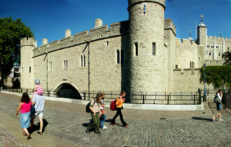
This photo of The Tower of London is part of one of the panoramic images found on the PanoramicEarth.com Tour of London. There are over 100 images taken from around London linked to an interactive map.

London for Less - FREE Theatre, Dining, or Sightseeing. Get the most of London with these London Guide Books

The Tower of London is another of those London buildings that is a world famous London icon. Built on the north bank of the Thames, opposite to the GLA Headquarters and near to Tower Bridge, the Tower of London evokes visions of imprisonment and torture through the ages of British Monarchy, being a place of execution of not a few kings and queens, along with other notable traitors or prisoners. Entrance to the Tower of London and the surrounding attractions of Tower Bridge Exhibition and the HMS Belfast is free with the London Pass.

Today the Tower of London is mostly known for two things – beheadings and the Crown Jewels. It was here that Anne Boleyn was beheaded by Henry VIII in 1536, supposedly for treason, though most likely for not bearing him a son. Most executions actually occurred on Tower Hill (now the site of a tube station), and only 7 individuals, including Anne Boleyn and Lady Jane Grey, were beheaded on the Tower Green, inside the walls of the Tower of London. The tower has also been a place of plotting and murder, most notably of the 2 sons of Edward IV by Richard, who became Richard III, as written about by Shakespeare. The bones of the 2 boys were discovered many years later under the foot of a stairway.

The Tower of London has long been home to the Crown Jewels. These used to be stored in the White Tower, and were almost successfully stolen by Thomas Blood and his gang in 1671. They were foiled by the unexpected appearance of the son of the guard and the Crown Jewels were saved. For his crimes, bizarrely, Thomas Blood was awarded a £500 per year pension and access to the Royal Court. The Jewels were then moved to a purpose built storeroom, where they remained until the Great Fire in the Tower in 1841. They are now on display in a safely guarded vault.

The central part to the Tower of London is the White Tower (originally called the Great Tower) built by William the Conqueror in 1078. The Tower, constructed of imported French stone, was built to protect both London from outside invasion, and to protect the occupying Normans from London. In the 12C King Richard the Lionheart dug a moat around the Tower and also erected a surrounding wall. This moat was improved in the 13C by Henry III and remained in use until it was drained in 1830. This also finished the effective use of the Tower of London as a fortress.

The Tower of London was converted by Henry III into a royal palace adding a number of outbuildings. Although the Royal Family have not lived here since the times of Oliver Cromwell, the Tower is still guarded as a royal Palace. The Tower has in the past also served time as a zoo, with animals on site from the 13th to the 19th Centuries. The Lion Gate is almost all that remains of this use, which used to be part of the Lion Tower, and the animals moved to the new London Zoo in The Regents Park.

The Tower of London actually contains some 20 distinct towers aside from the central White Tower. These include Beauchamp Tower, Bell Tower, Bloody Tower (or the Garden Tower), Bowyer Tower, Brick Tower, Broad Arrow Tower, Byward Tower, Constable Tower, Cradle Tower, Develin Tower, Deveraux Tower, Flint Tower, Lanthorn Tower, Martin Tower, Middle Tower, St. Thomas's Tower, Salt Tower, Wakefield Tower, Wardrobe Tower and the Well Tower.

Most tourists do not venture much further east than this in London unless they are visiting Greenwich. The nearest tube station to the Tower of London is Tower Hill, which is also an entrance point to the Docklands Light Railway.

Over 200 Destinations with HotelConnect

The full panoramic image taken of the Tower of London can be found on the London tour by PanoramicEarth.com. An enlargement of this photo can be found on Flickr.

For more articles on London see the London Index or select one of the labels at the bottom.

Sunday, November 26, 2006

Eccleston Square - London

Eccleston Square, near Victoria Station, London

This photo of Eccleston Square in London is part of one of the panoramic images found on the PanoramicEarth.com Tour of London. There are over 100 images taken from around London linked to an interactive map.

Plan your visit to London by taking advantage of these London Hotel Specials or Thomson City Breaks. Get the most of London with these London Guide Books

Eccleston Square lies just s short distance away from Victoria Station, it is a private square accessible only by those inhabiting the residences that line the square. There is very little information available about the history and the origin of the square available, and, unless you are inclined to climb the spiked fence, no public access.

Eccleston Square is notable for those institutions that occupy some of the surrounding buildings. Here you will find the London arm of the Passport Office (89 Eccleston Square), and the regular queues of people frantically trying to get rapid processing of lost, stolen or expired documents just before they go on holiday.

The Catholic Agency to Support Evangelisation (CASE) have their office at Number 39, having changed their name, after 100 years, from the Catholic Missionary Society. Other notable institutions around the square include the headquarters of the Buddhist Society (58 Eccleston Squar), which moved here in 1956, the year of the 2,500th celebration of the Buddha Jayanti, or the Buddha’s Enlightenment celebrations in India. At 32 Eccleston Square you will find the Garden Design department of the Inchbald School of Design.

You can find Eccleston Square on Tagzania

The nearest Station to Eccleston Square is Victoria Station.

Over 200 Destinations with HotelConnect

The full panoramic image taken from the top of Rose Gardens can be found on the London tour by PanoramicEarth.com. An enlargement of this photo can be found on Flickr

For more articles on London see the London Index or select one of the labels at the bottom.

Wednesday, November 22, 2006

Gabriel's Wharf Lookout - London

View over River Thames from Gabriel's Wharf lookout

Gabriel’s Wharf is found on the South Bank of the Thames, just a couple of minutes away from the Oxo Tower, apart half way between Waterloo Bridge and Blackfriars Bridge. At this point the promenade that runs from Wesminster all the way down to Tower Bridge juts out into the Thames a little providing an excellent place from which to admire the view up and down the river.

Set back from the Thames is a shopping area, called Gabriel’s Wharf, in which you will find a lovely collection independent small shops and boutiques selling a variety of arts and crafts, many them made on site by the shop owners. At the weekends there is also a craft market in the area. Gabriel’s wharf has, therefore, an refreshing display of both creative talent and entrepreneurial spirit sorely lacking in much of the rest of the city where large chain stores have taken over much of the areas.

From Gabriel’s Wharf lookout you can clearly see St Paul’s Cathedral and the skyline of the City of London. Oxo Tower is but a couple of minutes away. The tower also contains a number of galleries as well as a fantastic, and equally expensive, restaurant on the top floor with fabulous panoramic views up and down the Thames. About 5 minutes further on down the Thames you will find the Tate Modern and the Millennium Bridge. In the other direction is Waterloo Bridge and 5 minutes beyond that is the London Eye.

Gabriel’s Wharf is more often ‘discovered’ by people than deliberately visited, but it is well worth the effort for those wanting to discover a quieter spot in London offering original talent. Take a pause here before continuing your walk.

Gabriel’s Wharf is also the location of the Coin Street Festival in the summer. The nearest tube stations to Gabriel's Wharf are Waterloo and Blackfriars.

Over 200 Destinations with HotelConnect

The full panoramic image taken from the top of Rose Gardens can be found on the London tour by PanoramicEarth.com. An enlargement of this photo can be found on Flickr.

For more articles on London see the London Index or select one of the labels at the bottom.

Sunday, November 19, 2006

Victoria Memorial by Buckingham Palace - London

Victoria Memorial in front of Buckingham Palace

This photo of The Victoria Memorial is part of one of the panoramic images found on the PanoramicEarth.com Tour of London. There are over 100 images taken from around London linked to an interactive map.

Plan your visit to London by taking advantage of these London Hotel Specials or Thomson City Breaks. Get the most of London with these London Guide Books

The Victoria Memorial is a memorial to Queen Victoria, the longest reigning monarch in British history. The Memorial stands in the centre of the Queen’s Gardens in front of Buckingham Palace. In recent years much of the area around the Memorial has been pedestrianised, allowing visitors both easy access to the Memorial while also increasing the area you can safely stand on. From the steps of the Victoria Memorial you get a great view along The Mall to Admiralty Arch at the other end. Apart from Buckingham Palace, the memorial is surrounded by both Green Park and St. James Park.

The Victoria Memorial was built in the time when Rule Britania was a reality, and follows a nautical theme. The memorial, built in 1911 out of 2,300 tons of marble, is a combination of a central statue made by Sir Thomas Brock, surrounded by an area designed by Sir Aston Webb. The Victoria Memorial, some 82 feet high, is now a Grade 1 listed ‘building’.

The Victoria Memorial contains a large 4m statue of Queen Victoria seated on a throne facing down the Mall towards Admiralty Arch as shown in this picture. The throne and plinth she is sat on forms part of a square pillar or column supporting a bronze winged ‘Victory’ on the top. The two seated figures beside the Victory were donated by New Zealand. Plinths on the other tree faces of this central column support white marble statues of 3 angels representing the traditional Victorian values of Justice, Truth and Charity. Near the base of, and emerging from, this column 4 boats representing Britain’s rule over the oceans.

The Victoria Memorial surround is a walled area with steps up to the centre from both the Mall side and opposite on the side that faced Buckingham Palace (and is a good place to photograph the Palace). Bronze lions and men with torches guard either side of these stairways. The surround also includes large fountain basins which join the opposing stairways around either side of the fountain. At the midpoint of each wall above the fountain basins are further bronze figures.

The whole construction has earned the Victoria Memorial the nickname of “The Wedding Cake” as it represents the decoration on the top of one. In fact, if you get into a black cap and ask to be taken to ‘The Wedding Cake’ many drivers will automatically take you here to the Victoria Memorial.

Over 200 Destinations with HotelConnect.

The full panoramic image taken of the Victoria Memorial and Buckingham Palace can be found on the London tour by PanoramicEarth.com. An enlargement of this photo can be found on Flickr.

For more articles on London see the London Index or select one of the labels at the bottom.

Tuesday, November 14, 2006

The Rose Garden, Queen Mary Gardens, Regents Park

Roses in flower in the Queen Mary’s Rose Garden in The Regents Park in London

This photo from the Queen Mary’s Rose Garden in Regents Park, London is part of one of the panoramic images found on the PanoramicEarth.com Tour of London. There are over 100 images taken from around London linked to an interactive map.

Plan your visit to London by taking advantage of these London Hotel Specials or Thomson City Breaks. Get the most of London with these London Guide Books

The Rose Garden is part of the Queen Mary’s Gardens in The Regents Park. In fact many people refer to the whole of the Queen Mary Gardens as the Rose Gardens, though this is incorrect. Within the gardens are nearly 330 different varieties of roses, all planted out with labels indicating what they are. As such this Rose Garden should be a one stop reference point for those interested in roses.

In fact the list of plants here is impressive: There are 84 Formal Beds containing 80 varieties of Roses and a further 145 varieties are in the borders. The Rose Gardens also contains some 60 varieties of rambling or climbing roses, 41 varieties of Patio (miniature) Roses giving a total of 326 varieties and over 15,000 plants.

The focal point of the Rose Garden is the Rose Wheel, the circular area shown in this photo. A series of 10 planted beds radiate out from a focal bed, and are further surrounded by 10 other more rectangular planting beds. Around the whole of this are a number of benches set into alcoves formed by climbing roses. From the air the Rose Wheel takes on the appearance of a crop circle. Yet this is by no means the ends of the Rose Garden More beds of roses are spread out along and around the main lake within Queen Mary’s Gardens forming a glorious display of colour and smells. Put together this is a very popular place where people stroll gently or simply sit surrounded by flowers.

The Queen Mary’s Gardens occupy the whole of the 18 acres surrounded by the Inner Circle. The Inner Circle was first leased to the Royal Botanical Society and used as their garden. In 1932 the lease ran out and the garden was taken over by the Royal Parks and renamed as the Queen Mary’s Garden, after the wife of King George V. Here you will find a National Collection of delphiniums, herbaceous and Mediterranean borders, extensive lawns, an alpine island on the lake and, in the summer, a begonia garden and a sub-tropical border. The Queen Mary’s Gardens are also home to the Open Air Theatre and Garden Café.

Regents park is very close to Baker Street and many people walk through it from here to London Zoo. From Baker Street you will enter the park at the Boating Lake, and then you can cross a bridge, proceed up the path to Queen Mary Gardens. Another formal gardens within the Regents Park is Avenue Gardens.

Over 200 Destinations with HotelConnect

The full panoramic image taken from the top of Rose Gardens can be found on the London tour by PanoramicEarth.com. An enlargement of this photo can be found on Flickr.

For more articles on London see the London Index or select one of the labels at the bottom.

Finsbury Circus - London

People playing bowls in Finsbury Circus in the City of London

This photo of Finsbury Circus is part of one of the panoramic images found on The London Map from Panoramic Earth. There are over 100 images taken from around London linked to an interactive map.

Plan your visit to London by taking advantage of these London Hotel Specials or Thomson City Breaks. Get the most of London with these London Guide Books

Full 360° Panorama of Finsbury Cirus

Finsbury Circus is tucked away in the near to the City of London and definitely not on the beaten track for those visiting London. It is unusual in more ways than one. Unlike many other squares in London this one is elliptical, and in the centre is an immaculate bowling green used by the City of London Bowls Club, as evidenced by the people in white shown in this picture. The nearest Tube Station is Mooregate and it is also near to the Museum of London.

Finsbury Circus is a quiet place to let time pass in the summer. Much of the square is occupied by the bowling green, but there is plenty of seating area around this and some beautiful planted areas. While this image shows the bowling green, the full panoramic image also shows the bed behind where the plantations form the crest for the City of London. Finsbury Circus also contains a band stand and it is not uncommon to hear live jazz or other music drifting across the square in the summer.

The history of Finsbury Gardens goes back a long way, to Roman times, when the area, known as ‘Fesnbury’ and effectively a moor. In the early 15C the city wall was breached at this point and nearby Moorgate was completed. By the early 17C the area had been raised and planted with trees becoming a public park, the first in London, in 1606. The land of Finsbury Circus was acquired by the Corporation of London in 1900 and the bowling green laid in 1904.

None of the buildings around Finsbury Circus are original (William Montegue built some fine houses here around 1815), but those that do now surround the oval square are graceful curved terraces typically occupied by banks, insurance companies and the like. The HQ of British Petroleum is also currently located on Finsbury Circus.

An enlargement of this photo can be found on Flickr.

For more articles on London see the London Index or select one of the labels at the bottom.

Victoria Embankment Gardens - London

Victoria  Embankment Gardens next to Embankment Tube Station

This photo of The Victoria Embankment Gardens is part of one of the panoramic images found on the PanoramicEarth.com Tour of London. There are over 100 images taken from around London linked to an interactive map.

Plan your visit to London by taking advantage of these London Hotel Specials or Thomson City Breaks. Get the most of London with these London Guide Books

The Victoria Embankment Gardens are a lovely place to relax and have a picnic in the summer months when the sun is out and the plantations within the gardens are in bloom. This stretch of green nestled between Charring Cross and Embankment stations and running along the River Thames. The Gardens contain several notable statues and other features and also hosts free concerts, weather permitting, during the summer. The Victoria Embankment Gardens, being close to the aforementioned stations, are also close to the Strand, taking just a couple of minutes for a shopper to get to and escape the crowds.

The development of the Embankment was proposed by Sir Christopher Wren after the Great Fire of London, but took until 1862 for a scheme to be approved. At that time the embankment wall along the Thames was built, constructed of bricks and faced with granite the wall extends some 4m below the low water mark of the river and allowed for some mud flats to be reclaimed. The embankment wall also prevented flooding of the city.

The whole of the Victoria Embankment Gardens is broken into 3 sections covering 11 acres, with the one shown here being the largest. The main historical feature of the Gardens is the Water Gate, a triumphal entry to the Thames built for the Duke of Buckingham in 1626. The Gate used to access the Thames directly, but because of the construction of the Embankment, it now stands some 100m from the edge of the river.

The Victoria Embankment Gardens, like any well presented public park, also contains a number of statues of note worthies from times past. Included among the collection here are both statues of the Scottish Poet Robert Burns, and a statue of William Tyndale who first translated the Bible into English in 1484 and was promptly executed for doing so. This statue dates from 1884. Other little treats within the Embankment Gardens include a water fountain dedicated to Henry Fawcett by ‘his grateful country women’ and a soldier mounted on a camel next to the band stand dedicated to the Imperial Camel Corps.

Just on the opposite side of the River to the Embankment Gardens is the London Eye and London Aquarium (entrance free with The London Pass). The Embankment Gardens are also very close to Westminster Pier, a major departure point for ferries and tour boats on the Thames.

Over 200 Destinations with HotelConnect.

The full panoramic image taken of the Victoria Embankment Gardens can be found on the London tour by PanoramicEarth.com. An enlargement of this photo can be found on Flickr.

For more articles on London see the London Index or select one of the labels at the bottom.

New Panoramas on Panoramic Earth