Saturday, December 09, 2006

St. James Park - London

Geese in St. James Park, London

This photo of the view from St. James Park in London is part of one of the panoramic images found on the PanoramicEarth.com Tour of London. There are over 100 images taken from around London linked to an interactive map.

Plan your visit to London by taking advantage of these London Hotel Specials or Thomson City Breaks. Get the most of London with these London Guide Books

St. James Park is one of the Royal Parks in London and forms a triangle. At one end is Buckingham Palace and the park is bordered by The Mall, Horse Guards Parade (which passes Downing Street) and then Birdcage Walk. St. James Park is one of the smaller Royal Parks, covering only about 95 acres of land

A lake runs almost the full length down the centre. The lake is populated by a variety of fowl, including the geese you see here feeding off the grass. There are two islands in the lake (Duck Island and West Island, and a large fountain close to Duck Island at the eastern end. There is a lovely bridge which spans the lake in the middle linking the two sides of the park and offering great views back towards Westminster.

St James Park is mostly grassland with trees, although there are some flower plantings, especially towards the east end of the park, near to Horse Guards Parade. The Mall, which runs down one edge, links Buckingham Palace with Trafalgar Square, passing through Admiralty Arch. This road is closed to traffic on Sundays, bringing calm to the whole area and allowing this part of London space to breathe. Within the park is also a bandstand, and often live music, and a restaurant, close to where this picture was taken.

In the summer the park is generally full of people taking advantage of a space to relax and catch a bit of the sun. The eastern skyline is now dominated by the London Eye, whose pods rise above the top of Whitehall.

Like most of the Royal Parks, St. James Park owes it’s history to Henry VIII who brought the land for hunting. The area was marshy and often flooded by the Tyburn. Over the next 200 years various changes were made to the park, and the final shape that we have today settled into place. John Nash was one of the planners who worked on the layout of St. James Park.

Over 200 Destinations with HotelConnect.

The nearest tube stations include St. James Park, Westminster and Charring Cross. Green Park Tube is also close by.

The full panoramic image taken from the junction of St. James Park can be found on the London tour by PanoramicEarth.com. An enlargement of this photo can be found on Flickr. You can also find a marker for resturant in St. James Park on Tagzania.

For more articles on London see the London Index or select one of the labels at the bottom.

Southwark Bridge - London

Southwark Bridge across the River Thames in London

This photo of the view of Southwark Bridge London is part of one of the panoramic images found on the PanoramicEarth.com Tour of London. There are over 100 images taken from around London linked to an interactive map.

Plan your visit to London by taking advantage of these London Hotel Specials or Thomson City Breaks. Get the most of London with these London Guide Books

Southwark Bridge spans the River Thames in London linking the City of London with Southwark. The next bridge downstream is London Bridge (often confused with Tower Bridge), while upstream is the Millennium Bridge (for pedestrians only) and then Balckfriars Bridge.

There are many important sites close to Southwark Bridge, especially along the southern bank of the Thames. Proceed upriver and you will quickly pass the Rose Theatre Exhibition, the Globe Theatre and then the Tate Modern. Travel in the other direction and you will find the Clink Prison Museum, Golden Hind replica boat and then Southwark Cathedral. St. Paul’s Cathedral is not too far away on the northern side of the river. It is easy to spend most of the day here, and some of the attractions are free with the London Pass.

The first bridge crossing the Thames at this point was not built until 1819. It was an iron bridge designed by John Rennie (who also designed the Serpentine Bridge in Hyde Park), and featured in Charles Dickens' Little Dorrit.

The current Southwark Bridge opened in 1921 and is now maintained by the Bridge House Estates, which is a charitable trust overseen by the Corporation of London. Southwark Bridge is often used as a coach park at the weekends, and it can be hard to find a place to look up or down the Thames given the number of coaches that can be parked here.

Over 200 Destinations with HotelConnect.

The nearest tube stations include Mansion House, London Bridge and Cannon Street.

The full panoramic image taken from the junction of Southwark Bridge can be found on the London tour by PanoramicEarth.com. An enlargement of this photo can be found on Flickr. You can also find a marker for Southwark Bridge on Tagzania.

For more articles on London see the London Index or select one of the labels at the bottom.

Serpentine Bridge - London

Serpentine Bridge in Kensington Gardens and Hyde Park

This photo of the view of the Serpentine Bridge London is part of one of the panoramic images found on the PanoramicEarth.com Tour of London. There are over 100 images taken from around London linked to an interactive map.

Plan your visit to London by taking advantage of these London Hotel Specials or Thomson City Breaks. Get the most of London with these London Guide Books

The Serpentine Bridge spans the Serpentine in Hyde Park at the north end of Exhibition Road. This road then becomes West Carriage Way, which continues north and separates Hyde Park from Kensington Gardens. From the Serpentine Bridge you get a great view down the Serpentine east, towards the West End of London.

The Serpentine is a man made lake covering some 40 acres, created by Queen Caroline in the 1730 by damning Westbourne Stream. Unlike other man made lakes of the period, the Serpentine was given a natural curve, a design that was quickly copied in most other grand gardens of the time. The Queen also took about 300 acres of Hyde Park and to make Kensington Gardens to go with Kensington Palace. Hyde Park was then separated from Kensington Gardens by a ha-ha.

Like the rest of the parkland, the lake here officially divides into two. The area towards the West End is the Serpentine (situated in Hyde Park), while the lake on the other side of the bridge is called Long Water and lies in Kensington Gardens. The Italian Gardens are at the far end of Long Water and there is also a statue of Peter Pan. The first wife of Percy Shelley, a famous 19C writer, drowned herself in the Serpentine in 1818. Percy later married Mary, who wrote Frankenstein.

The bridge itself is more recent and dates from around the 1820s by John Rennie when King George IV was renovating the park. Near to the bridge you will find the Serpentine Gallery, Diana Memorial Fountain and the Albert Memorial.

If you follow Exhibition Road south out of the park then you will be taken towards South Kensington and the Museum district where you will find the Victoria and Albert, Science and Natural History Museums (along with the Earth Galleries).

Over 200 Destinations with HotelConnect.

The nearest tube station is Hyde Park Corner, while South Kensington is about 10 minutes away down Exhibition Road.

The full panoramic image taken from the junction of the Serpentine Bridge can be found on the London tour by PanoramicEarth.com. An enlargement of this photo can be found on Flickr. You can also find a marker for Serpentine Bridge in Hyde Park on Tagzania.

For more articles on London see the London Index or select one of the labels at the bottom.

Friday, December 08, 2006

Serpentine Gallery in Kensington Gardens

Serpentine Gallery in Kensington Gardens

This photo of the view of the Serpentine Gallery in Kensington Gardens, London is part of one of the panoramic images found on the PanoramicEarth.com Tour of London. There are over 100 images taken from around London linked to an interactive map.

Plan your visit to London by taking advantage of these London Hotel Specials or Thomson City Breaks. Get the most of London with these London Guide Books

The Serpentine Gallery is surrounded by Kensington Gardens and Hyde Park, just a short distance form the Serpentine. It looks nothing like a traditional gallery, being housed in a Grade II listed former tea pavilion that was built in 1934. In 1998 the Serpentine Gallery was refurbished with a £4 million grant.

The grounds at the entrance to the Serpentine Gallery house a permanent work dedicated to Princess Diana, former patron of the Serpentine Gallery. This piece was made by Ian Hamilton Finlay and Peter Coates.

In contrast to the classical surroundings, many of the exhibitions at the Serpentine Gallery feature modern artists, and the list of those who have exhibited here is long and prestigious, including Henry Moore, Bridget Riley, Andy Warhol, Man Ray, Damien Hirst and Rachel Whiteread to name a few.

Unlike many other galleries in London, the special temporary exhibitions at the Serpentine Gallery remains free for all to visit. The gallery used to only be open during the summer months, but this may now have changed. Check the Serpentine Gallery website for current exhibition information and opening times.

Given the patronage of the late Princess Diana of the Serpentine Gallery, it is fitting that the Diana Memorial Fountain is just across the road from the gallery near to the Serpentine lake. Also near to the Serpentine Gallery are the Albert Memorial and the Royal Albert Hall, while Hyde Park Corner, and the Wellington Arch, are just a few minutes away.

Over 200 Destinations with HotelConnect.

The nearest tube station is Hyde Park Corner, while South Kensington is about 10 minutes away down Exhibition Road and past the V&A and Science Museums.

The full panoramic image taken from the junction of the Serpentine Gallery can be found on the London tour by PanoramicEarth.com. An enlargement of this photo can be found on Flickr. You can also find a marker for Parliament Square on Tagzania.

For more articles on London see the London Index or select one of the labels at the bottom.

Parliament Square - London

Parliament Square with 2012 Olympic flags and Brian Haw anti war protest

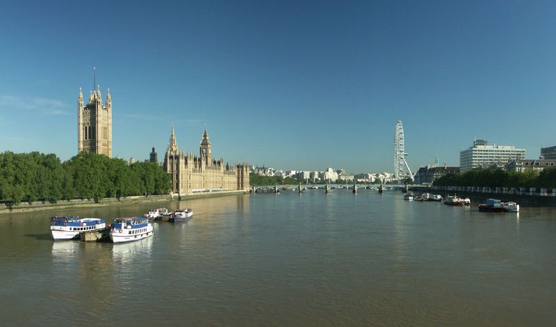
This photo of the view of Parliament Square in London is part of one of the panoramic images found on the PanoramicEarth.com Tour of London. There are over 100 images taken from around London linked to an interactive map.

Plan your visit to London by taking advantage of these London Hotel Specials or Thomson City Breaks. Get the most of London with these London Guide Books

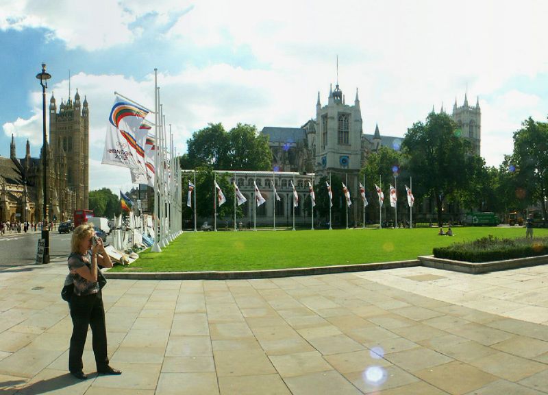
Parliament Square is, as the name suggests, just outside Parliament and the Palace of Westminster. The square is surrounded by official and imposing buildings including Westminster Abbey and St. Stephens Tower (containing the bell Big Ben). Also here is Protcullis House containing the offices for many of the MPs, completed in 2001.

Parliament Square has often been used as a platform for protest or publicity. Here the two collide as the banners, erected during the 2012 London Olympic bid promote the event, while along the ground are the posters and placards erected in support of Brian Haw and the peace protest against the War in Iraq. The latter are not welcome by the establishment and in May of 2006 the police removed most of it in a late night operation. Ironically, this action was overseen by a statue of Winston Churchill, defender of British freedoms, which is being photographed by the lady in the foreground.

Equally ironic is the proposal for a statue of Nelson Mandela, another champion of freedom, to be placed in the square. One can only speculate about his opinion of the State’s treatment of the current protest there. There is also a statue of Abraham Lincoln in Parliament Square.

The effectiveness of the Brian Haw protest (virtually unbroken since 2001) resulted in a new clause being introduced into the Serious Organised Crime and Police Act of 2005 banning all forms of public protest from the square without permission from the police. It is really difficult to imagine how this protest in Parliament Square constitutes a serious organised crime, but it is evident that people in power do not want him there.

Parliament Square has often been the destination for marches protesting or demonstrating in London for one thing or another. It was ‘reclaimed’ in May 2000 by the Reclaim the Streets protest group and turned into allotments. Other notable protests to focus on Parliament Square include those in opposition to the War in Iraq in 2003, and the Countryside Alliance in opposition to the ban on fox hunting.

Parliament Square became surrounded by traffic in 1926, and is now very busy almost all the time. During New Years Eve it is filled with people waiting for Big Ben to bring in the new year, and often now caught in the midst of firework displays from the London Eye and the Thames.

Over 200 Destinations with HotelConnect.

The nearest tube stations include Westminster and St. James Park.

The full panoramic image taken from the junction of Parliament Square can be found on the London tour by PanoramicEarth.com. An enlargement of this photo can be found on Flickr. You can also find a marker for Parliament Square on Tagzania.

For more articles on London see the London Index or select one of the labels at the bottom.

Oxford Street and Fruit Stall

Fruit Stall on junction of Oxford Street and New Bond Street, London

This photo of the view of Oxford Street in London is part of one of the panoramic images found on the PanoramicEarth.com Tour of London. There are over 100 images taken from around London linked to an interactive map.

Plan your visit to London by taking advantage of these London Hotel Specials or Thomson City Breaks. Get the most of London with these London Guide Books

Oxford Street has to be one of the most famous shopping areas in London. Sadly it is dominated by one high street store after another with little to differentiate it from other high streets except size. With some 300 shops lining nearly 2 miles from Tottenham Court Road to Marble Arch.

Oxford Circus is about half way along, forming an extremely busy junction with Oxford Street and Upper / Lower Regent Street. Near here you will find a few stores that have existed for more than a couple of years, including John Lewis, which has been on site since 1895, though the current building dates from 1960, the previous one being a victim of bombing in WWII. John Lewis store is unusual in that the principle beneficiaries of the generated profits are the workers, who are considered Partners.

Just behind John Lewis is Cavendish Square, a good place to relax if it is sunny. Further along Oxford Street you will find Selfridges, another world famous store, which opened in 1909. The highly profitable placement of the perfume section on the ground floor has been much copied by department stores around the world. It is hard to imagine that much of the rest of Oxford Street will remain in place for quite so long. The southern end of Baker Street joins Oxford Street next to Selfridges, linking the area to The Regents Park and Baker Street Tube.

The fruit stall you see in this picture is found at the junction of Oxford Street and New Bond Street (where you will find very expensive tailors, jewelers and the like). These little stores are a common site in London, providing fresh fruit at often lower prices than the supermarkets. Just north off Oxford Street from this point is the Wallace Collection in Manchester Square.

Oxford Street has existed since Roman times, linking London to Oxford. It used to be known as Tyburn Street after the River Tyburn which now runs underneath it. In the 18C it was notorious as the final route for prisoners on their way to the gallows at Tyburn (husbands been taken shopping along Oxford Street may feel the same way today!). The surrounding fileds were brought by the Earl of Oxford in 18C and developed into what has become the current shopping district.

Over 200 Destinations with HotelConnect.

The tube stations that serve Oxford Street include Tottenham Court Road, Oxford Circus, Bond Street and Marble Arch.

The full panoramic image taken from the junction of New Bond Street and Oxford Street can be found on the London tour by PanoramicEarth.com. An enlargement of this photo can be found on Flickr. You can also find a marker for New Bond Street on Tagzania.

For more articles on London see the London Index or select one of the labels at the bottom.

Neal Street - London

Neal Street in London

This photo of the view of Neal Street in London is part of one of the panoramic images found on the PanoramicEarth.com Tour of London. There are over 100 images taken from around London linked to an interactive map.

Plan your visit to London by taking advantage of these London Hotel Specials or Thomson City Breaks. Get the most of London with these London Guide Books

Finding out information on Neal Street is like looking up earth in the Hitchhikers Guide. Not quite ‘Mostly Harmless’, but almost as brief. Neal Street is a bustling shopping road, mostly pedestrianised, linking Shaftesbury Avenue to Covent Garden in the London Borough of Camden. Many of the shops along it sell modern fashion items mostly aimed at the modern, young and fashion conscious.

However, there are a number of other shops on Neal Street that, unlike a number of the clothing shops that come and go with the seasons, have remained in place for quite some time. These include the Kite Store at 48 Neal Street, and Neals Yard which sells a vast range of health food products. At the top of Neal Street (actually in Monmoth Street) is a good second hand jazz record shop.

Naturally it is risky listing the shops, pubs and restaurants in any London street, and Neal Street is no different. They tend to move on and change, making any effort to tell you what is there now hopelessly difficult. Neal Street is worth a stroll down, a browse along, as at least this is still one place in London which has yet to be dominated by the monotony of urban chain stores.

In the holiday season Neal Street can become very crowded, and even more so during the sales season.

Over 200 Destinations with HotelConnect.

The nearest Tube station to Neal Street is Covent Garden, but Tottenham Court Road and Leicester Square are also nearby.

The full panoramic image taken from Neal Street can be found on the London tour by PanoramicEarth.com. An enlargement of this photo can be found on Flickr. You can also find a marker for Neal Street on Tagzania.

For more articles on London see the London Index or select one of the labels at the bottom.

Italian Gardens in Kensington Gardens, London

 Italian Gardens Fountains in Kensington Gardens

This photo of the view of The Italian Gardens in Hyde Park, London is part of one of the panoramic images found on the PanoramicEarth.com Tour of London. There are over 100 images taken from around London linked to an interactive map.

Plan your visit to London by taking advantage of these London Hotel Specials or Thomson City Breaks. Get the most of London with these London Guide Books

The Italian Gardens in Kensington Gardens are the result of nearly 200 years of activity by the kings and queens of England in Hyde Park. The Italian Gardens are on the north edge of the park, just inside Lancaster Gate, at the top of Long Water and just to the west of West Carriage Drive. At the other end of Kensington Gardens you will find the Albert Memorial and the Serpentine Gallery.

The Italian Gardens contain 4 fountains set in octagonal ponds set around one smaller central fountain, also set in an octagonal pond. At the north end there is a shelter which used to be the steam powered pump house that provided water for the Long Water. This is decorated with 3 heads above each arch, one central male face flanked by female faces. The edge of the fountain area is lined by stone urns with dolphins and yet more ideal heads, and at the south end of the Italian Gardens the water cascades down a sculpture of water nymphs by John Thomas into the Long Water.

Half way down the eastern edge of the Italian Gardens is a statue to Dr. Edward Jenner who perfected the smallpox vaccine in 1796 and provided the world with the first steps towards the eradication of this virus which had plagued humans for thousands of years. The statue used to be in Trafalgar Square.

Back in 12C Hyde Park belonged to a manor used by monks. It was seized by Henry VIII and turned into a Royal Hunting Ground around 1530. In 1637 the park was opened to the public then in the late 17C King William and Queen Mary brought Nottingham House and renamed it Kensington Palace.

We owe many of the modern features of the Kensington Gardens to Queen Caroline in the 18C who, being a keen gardener, took almost 300 acres from Hyde Park and turned them into Kensington Gardens to go with Kensington Palace. She separated it from Hyde Park by a ha-ha and created the Serpentine by damning Westbourne Stream. Queen Victoria commissioned the Italian Gardens at the same time as the Albert Memorial

There are many other famous monuments around Kensington Gardens and Hyde Park including the Albert Memorial, Diana Memorial Fountain, Marble Arch, Wellington Arch and numerous other statues.

Over 200 Destinations with HotelConnect.

The nearest Tube station to the Italian Gardens is Lancaster Gate.

The full panoramic image taken from the Italian Gardens can be found on the London tour by PanoramicEarth.com. An enlargement of this photo can be found on Flickr. You can also find a marker for the Italian Gardens on Tagzania.

For more articles on London see the London Index or select one of the labels at the bottom.

Tuesday, December 05, 2006

Wallace Collection in London

Wallace Collection in Manchester Square

This photo of the view of The Wallace Collection in London is part of one of the panoramic images found on the PanoramicEarth.com Tour of London. There are over 100 images taken from around London linked to an interactive map.

Plan your visit to London by taking advantage of these London Hotel Specials or Thomson City Breaks. Get the most of London with these London Guide Books

The Wallace Collection started life as a private collection built up during the 18th and 19th centuries by the Marquesses of Hertford. The final collector was Sir Richard Wallace, the son of the 4th Marquess. Upon his death his widow, Lady Wallace, donated the entire collection to the nation in 1897. Hertford House, the former London residence of the Wallaces, was converted into a museum and the collection was opened to the public in 1900.

Among the more famous pieces is The Laughing Cavalier by Hals, and works by Titian and Rembrandt. The Wallace Collection also contains a large number of 18th Century French wokrs including paintings, porcelain, furniture and gold boxes. Together this is reputed to be one of the largest collections of French works outside of France. However, the Wallaces did not stop there and you will also find British arms and armour as well as other European and Oriental objects.

Thankfully, entrance to the Wallace Collection is still free, and the central courtyard to the house was given a glass roof a few years ago so visitors will not be caught out in the weather. Unfortunately, the same can not be said for Manchester Square, on which the Wallace Collection is located just off Oxford Street, which is kept under lock and key for the use of the surrounding residences only.

Over 200 Destinations with HotelConnect.

The nearest Tube stations the Wallace Collection are Bond Street and Marble Arch on Oxford Street, though Baker Street is not too far away.

The full panoramic image showing the front of Hertford House and Manchester Square can be found on the London tour by PanoramicEarth.com. An enlargement of this photo can be found on Flickr. You can also find a marker for the Wallace Collection on Tagzania.

For more articles on London see the London Index or select one of the labels at the bottom.

Lambeth Bridge - London

View of Palace of Westminster and London Eye from Lambeth Bridge

This photo of the view of Lambeth Bridge in London is part of one of the panoramic images found on the PanoramicEarth.com Tour of London. There are over 100 images taken from around London linked to an interactive map.

Plan your visit to London by taking advantage of these London Hotel Specials or Thomson City Breaks. Get the most of London with these London Guide Books

There has been a Thames crossing at the current site of Lambeth Bridge for centuries, though the first bridge crossing here was built in 1862. The original Lambeth Bridge was a toll suspension bridge, but the approaches were too steep for most coaches to use. The current bridge was built in 1932 by King George V. At either end are Obelisks topped with pine cones – the traditional symbol of hospitality since Roman times.

Lambeth Bridge links Westminster with Lambeth and offers great views back up the Thames towards Westminster Bridge. Just on the south side of Lambeth Bridge is the Museum of Garden History and Lambeth Palace, the London residence of the Archbishop of Canterbury. There is a peasant walk along the Thames opposite the Houses of Parliament from Lambeth Bridge to Westminster Bridge.

On the north side, Lambeth Bridge joins up to Horseferry Road and Millbank. Here also is the southern end of Victoria Tower Gardens, which link the bridge with the Palace of Westminster. These gardens contain a number of statues, including a suffragette and a cast of Rodin's Burghers of Calais.

As can be seen from this photo, looking down the river towards Westminster from Lambeth Bridge you get a great view of the Palace of Westminster, partially shielded by the trees of the Victoria Tower Gardens. The rest of London appears on the skyline above Westminster Bridge, while on the left the London Eye towers over the surrounding buildings.

Up until 1750 the Thames crossing here used to be by ferry, which had the unfortunate reputation for sinking. In 1633 it did so with the belongings of Archbishop Laud, and then in 1656 carrying Oliver Cromwell’s coach. Early attempts to secure permission for a bridge received successful opposition from the Company of Watermen. However, the opening of Westminster Bridge in 1750 killed off the ferry trade. Another 100 years passed before the first Lambeth Bridge was built.

Over 200 Destinations with HotelConnect.

The nearest Tube stations to Lambeth Bridge include Lambeth North and Westminster.

The full panoramic image taken Lambeth Bridge can be found on the London tour by PanoramicEarth.com. An enlargement of this photo can be found on Flickr. You can also find a marker for Lambeth Bridge on Tagzania.

For more articles on London see the London Index or select one of the labels at the bottom.

Jubilee Gardens - London

Jubilee Gardens next to London Eye

This photo of the view of Jubilee Gardens in London is part of one of the panoramic images found on the PanoramicEarth.com Tour of London. There are over 100 images taken from around London linked to an interactive map.

Plan your visit to London by taking advantage of these London Hotel Specials or Thomson City Breaks. Get the most of London with these London Guide Books

Jubilee Gardens is a new open space in London next to the London Eye, overlooking the Thames in the London Borough of Lambeth. The gardens were created in 1977 to mark the Silver Jubilee of Queen Elizabeth II, and were opened by the Queen on 9 June of the same year. As such, the gardens form part of the Jubilee Walk, which takes in various locations around London.

As mentioned, Jubilee Gardens are close to the London Eye, one of the most popular tourist attractions in London, and also close to the London Aquarium (free entrance with the London Pass), the Salvador Dali Exhibition and a short distance from where the steps from Westminster Bridge descend to the South Bank. Hungerford Bridge also crosses the Thames next to the park providing aceess to Embankent and Charring Cross. In the summer it is a great place to relax and watch the crowds bustle past along the South Bank while the London Eye continues it’s slow and graceful rotations.

At present, Jubilee Gardens is a grassed area surrounded by trees and overseen by local community groups and businesses. Following local consultation in December 2004 it was decided to turn the area into a park and the Jubilee Gardens Steering Group was formed to oversee the project. Four designs were short listed from a competition of ideas for the space and were presented to the public in May of 2005. In June 2005 it was announced that West8 have been selected to take their concept forward.

West8 sees Jubilee Gardens as ‘an holistically-designed, organic, lush and green park’, and plan an undulating area set with curved paths and raised lookout points. It will be planted with a variety of trees and flowers providing blooms throughout the year. Based on a ‘metaphor of Green Trafalgar’, it will transform Jubilee Gardens from a plain flat area into a dynamic and varied open space. More information can be found on the Jubilee Gardens website. In May 2006 Lambeth Council granted planning permission for the project to proceed, but as yet there is no date set for the commencement of the works which will probably see Jubilee Gardens close for several months.

Over 200 Destinations with HotelConnect.

The nearest Tube stations to Jubilee Gardens include Waterloo, Westminster and Embankment

The full panoramic image taken of the Jubilee Gardens can be found on the London tour by PanoramicEarth.com. An enlargement of this photo can be found on Flickr. You can also find a marker for Jubilee Gardens on Tagzania.

For more articles on London see the London Index or select one of the labels at the bottom.

Friday, December 01, 2006

Green Park Tube Station

View down Piccadilly outside Green Park Tube Station

This photo of the view from outside Green Park Tube Station in London is part of one of the panoramic images found on the PanoramicEarth.com Tour of London. There are over 100 images taken from around London linked to an interactive map.

Plan your visit to London by taking advantage of these London Hotel Specials or Thomson City Breaks. Get the most of London with these London Guide Books

Green Park Tube Station is, as you might expect, located very close to Green Park in Zone 1, and one exit gives access directly to the park. There is very little of the tube station to see above ground except for a couple of signs beside the road and some stairs descending to the bowels of London.

Green Park Tube Station buried at the northern most point of the Green Park, next to the Ritz Hotel and about half way along Piccadilly, which links Hyde Park Corner to Piccadilly Circus. This road is normally very busy, unlike the impression given in this photograph, and standing in the middle of the road taking pictures is not (normally) recommended.

There is a lot to see and do around the station apart from the park itself. Walking into the park down the path there you will pass Spencer House, one of the most ambitious aristocratic residences in London, on the right and, a little further on, is St. James Palace and Clarence House. At the bottom of Green Park you will exit through some iron railings onto Queens Gardens in front of Buckingham Palace. The Victoria Memorial, sometimes called the Wedding Cake because of the shape, stands in the middle of this with Queen Victoria looking down the Mall towards Admiralty Arch at the other end.

You will often find artists selling paintings along the railings of the park. The surrounding shopping area is fairly expensive serving the tastes of those living in Mayfair. The Mayfair Curzon cinema is very close by, and the Shepherd Market is also worth a browse. The USA Embassy is just north of this in Grosvenor Square.

Green Park Tube Station was originally called Dover Street and opened in 1906, then rebuilt in 1933 and the ticket hall moved below ground. Several busses run along Piccadilly serving the station including the 8, 9, 14, 19, 22 and 38.

Over 200 Destinations with HotelConnect

The full panoramic image taken outside Green Park Tube Station can be found on the London tour by PanoramicEarth.com. An enlargement of this photo can be found on Flickr. You can also find a marker for Green Park Tube Station on Tagzania.

For more articles on London see the London Index or select one of the labels at the bottom.

Thursday, November 30, 2006

Hyde Park Corner and Wellington (Constitution) Arch

Wellington Arch on Hyde Park Corner, also called Constitution Arch

This photo of the view of Wellington Arch at Hyde Park Corner in London is part of one of the panoramic images found on the PanoramicEarth.com Tour of London. There are over 100 images taken from around London linked to an interactive map.

Plan your visit to London by taking advantage of these London Hotel Specials or Thomson City Breaks. Get the most of London with these London Guide Books

Hyde Park Corner, like Marble Arch at the other end of Park Lane, is a very busy gyro system for traffic and a tube station. Sitting on the south-east corner of Hyde Park, it is formed by the convergence of Park Lane, Knightsbridge, Piccadilly, Grosvenor Place and Constitution Hill. The road from Knightsbridge joins to Piccadilly via an underpass running under Hyde Park Corner.

All these roads link very important places in London, Piccadilly runs, well, to Piccadilly Circus along the top of Green Park. In the other direction Kiightsbridge will pass the Brompton Oratory and head on to the Natural History, V&A and Science Museums. Head up Park Lane to get to Marble Arch and the shopping Mecca of Oxford Street. Wander along Constitution Hill to get to the front of Buckingham Palace and the Victoria Memorial. And finally Grosvenor Place will take you to Grosvenor Gardens and Victoria Station.

Thankfully, there is also an extensive set of underpass tunnels for pedestrians linking the various pavements around Hyde Park Corner, which avoids the need to play some demented version of Frogger trying to get from Green Park to Hyde Park. As you cross over though you will have to notice the triumphal Arch in the middle of Hyde Park Corner.

This is Wellington Arch (also called Constitution Arch) was built between 1826 and 1830 to counterbalance Marble Arch at the top end of Hyde Park. It was designed by Demicus Burton and the exterior is fairly plain as the cost of refurbishing Buckingham Palace at the same time consumed too much money for extensive decoration of the Arch to be possible.

Originally Wellington Arch stood opposite Apsley House just a short distance away, but was moved to the current location in 1882 when the surrounding roads were widened and Hyde Park Corner became an island surrounded by roads. Wellington Arch was originally topped by a statue of Sir Arthur Wellesley, 1st Duke of Wellington, a soldier and Prime Minister. This was removed in 1912 and then replaced with the current bronze quadriga showing the Angel of Peace descending on the chariot of war. Unfortunately, the optimism of the early 1900s was not reflected by the conflicts of the subsequent years.

Over 200 Destinations with HotelConnect.

The nearest tube station: Hyde Park Corner, though Green Park is also quite close.

The full panoramic image taken of the Hyde Park Corner can be found on the London tour by PanoramicEarth.com. An enlargement of this photo can be found on Flickr. You can also find a marker for Wellington Arch on Tagzania.

For more articles on London see the London Index or select one of the labels at the bottom.

New Panoramas on Panoramic Earth