Showing posts with label 360 panorama. Show all posts

Monday, March 16, 2015

Mika Salmi Panoramic Photographer from Finland

Panorama of Utransaari 2 supplied by Panoramic Earth


Mika Salmi recently joined the Panoramic Earth community, uploading some pictures from Finland. His photography mostly focuses on the areas around Lappeenranta, where he was born, and Joensuu, where he studied Information Technology. Photography has always been a hobby, and recently he has become much more interested in it, learning about panoramic photography and High Dynamic Range (HDR) imaging in the last six years. Like most photographers, Mika says, “I'd like to think that I've done something right since some people have liked at least some of my pictures, but I'm quite self-critical about my pictures.”

While he likes the idea of HDR images, Mika recognizes that they have a specific feel about them that can feel somewhat artificial. Nowadays he is trying to use it, “more realistically and create pictures that don't necessarily look like HDR images straight away.” He enjoys outdoors, and enjoys shooting natural landscapes, which clearly shows in his work. He is also quite at home working in urban landscapes and interiors. In addition to the images he has on Panoramic Earth, Mika has also uploaded some of his work onto Flickr and 360cities. From photography, he is developing an interest in videography and has friends working in the aerial photography business in Finland.

Find Mika on Facebook

Friday, July 25, 2014

Panoramic Earth Moves to HTML5

It has been a while coming, but Panoramic Earth is now moving to an HTML5 panorama viewing engine. Up to now the site has been using a Flash version of KRPano. While this has proved great for several years, Flash is not well supported by mobile devices, especially if made by Apple. As the number of mobile users has increased, so this anomaly has been a growing issue.


For a while it has been possible to render equirectangular spherical panoramic images in HTML5, but not cylindrical. This meant that only part of the content of the site could be viewed with the new viewer. However, things have now moved on meaning that over the next few days all the 10,500 plus panoramas will be converted to the new version.
The viewing engine still comes from KRPano, one of the most popular panorama viewers on the market. With it come some new functions as well. Practically speaking, viewers on computers will notice little difference, but for mobile devices this will transform their user experience.

Saturday, March 08, 2014

Makarska and the Dalmatian Coast in Croatia

Makarska from the Statue of St Peter © Peter Watts 
Makarska is very picturesque town in the Dalmatian Coast in Croatia. Nestled between the Biokovo mountains and the Adriatic Sea at the mouth of the Makarska Riviera, it is a very popular tourist destination during the summer months. The whole area is steeped in history, having been occupied for thousands of years and is even written about in Egyptian and Cretan tablets. During Roman times it was called Muccurum, and remains of Roman rule can still be seen in the region, not least in Split which contains the remains of Diocletian's Palace.

The image shown here is one of a collection taken whilst on a cruise down the Dalmatian Coast. Such trips are popular as they offer the opportunity to move from one town or island to another in comfort and ease, providing a new place to explore each evening.

The panorama below shows a view from the other side of the bay. Makarska has plenty of holiday apartments and hotels to suit all budgets and is well worth exploring if you are travelling through the region.


Written by Peter Watts

Wednesday, December 11, 2013

St Martin in the Fields Church Virtual Tour


St Martin in the Fields 360 Panorama Image

St Martin in the Fields is a famous church in London, found on the north east corner of Trafalgar Square. The current church was designed by James Gibbs in the early 18th century. At the time it was built, the church stood in a field part way between the City of Westminster and the City of London. In 2006 a Roman grave was found on the site, indicating that the site had been used as a religious place of worship for hundreds of years.

This interactive, 360 panorama shows the interior of the church. It was taken by Peter Watts in September 2013.


Today, St Martin in the Fields is a popular concert venue, with classical concerts and organ recitals often being held in the church itself. Beneath the church, in the Crypt Cafe, jazz concerts are often held. Being right next to Trafalgar Square, the church is also a popular tourist attraction. It is also the parish church of Buckingham Palace, Number 10 (Downing Street) and the Admiralty.

Thursday, March 28, 2013

Gigapixel 360 Panorama from Gale Crater on Mars


The Curiosity Rover on Mars has been busy taking pictures. About 405 of them with the two cameras on the vehicle's mast. These have been combined to produce a spherical panorama measuring 90000x45000 pixels (or 4 billion pixels). The result is a stunning spherical, gigapixel image of the Gale Crater

For those who want the technical details, this was taken betwen Martian solar days 136-149
using both the 100mm Narrow Angle Camera (NAC), and 34mm Medium Angle Camera (MAC). Though not the largest Gigapixel image ever produced, it is probably the most amazing in terms of technical achievement. 

Though you may not be able to produce an image of this kind, you can get yourself a bit of the Mars mission. Ok, so it would be in Lego, but someone has put together plans for how to build your own Lego Curiosity Rover and landing stage

Monday, March 11, 2013

360 Panorama of London from The Shard


London has a new viewing platform, on level 72 of The Shard, the second highest building in the EU. To celebrate this The Shard has produced an interactive 360 virtual tour panorama showing the view over London. Taken from 245m above ground level, the panorama is peppered with hotspots giving information about various landmarks and places of interest. 

Also within the image are links to various sounds recorded around the city as part of the London Sound Survey Project. There is the famous peal of bells from St Paul's Cathedral, monkeys from London Zoo and MP's (sounding much like the monkeys) from within Parliament.

The Shard is the tallest building in the United Kingdom. It is fully 309.6m (1,016 ft) tall with 95 floors topped out with a spire. You can find out more about it on Wikipedia.

This is not the biggest panorama of London. That honour goes to the massive 320 +Gigapixel image taken from BT Tower, which was the largest ever created in the world. However, I prefer this one for the interactivity and clarity of landscape.

So what is your favourite part of this image?

Monday, March 04, 2013

Largest Gigapixel 306 Panorama Ever Shows London from BT Tower


Screen Shot of BTs London Gigapixel PanoramaBT now own the largest 360 panorama in the world. Taken from the top of the BT tower during the London Olympics in 2012, it shows of the heart of the city. To mark the event BT have hidden 3 images of their Buzby mascot within the image. The lucky finders will receive prizes. It beats the 80 gigapixel image of London released in 2010 by quite some distance.

This 320 gigapixel image was created by stitching together some 48,640 individual frames taken with  four Canon EOS 7D cameras. It is hosted by 360 Cities. The image is most impressive in the mid-distance range as the day on which it was taken is quite hazy resulting in loss of clarity at long range. As with all images of this kind, there are increasing stitching errors as one gets closer to the tower, and the office buildings nearby are suffering some a degree of 'flexability'.

All the landmarks are clearly visible, and by the looks of the scarring on the lower end of Regents Park, it would appear that an exhibition event has just left the park. 

A collection of over 300 panoramas taken around the city, linked to Google Maps, can be found on this London virtual tour map.

Tuesday, December 25, 2012

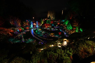
Christmas Lights at Butchart Gardens


Butchart Gardens are a very popular tourist attraction near to Victoria on Vancouver Island. Every year the gardens are decorated with extensive lights, themed on the Twelve Days of Christmas. Around the gardens you will find various installations depicting the 12 days, from a partridge in a pear tree to the 12 drummers drumming.

It can take a couple of hours to go around the gardens. It is often raining here, and free umbrellas are provided. While this can make for a somewhat damp evening, it does mean that the lights reflect wonderfully in the wet stone.

Taking virtual tour images under these conditions can be quite tricky. The paths are narrow and often full of people. It is dark and very long exposures are required. The best time to do photography is towards the end of the evening when the crowds have thinned out. At that time it is possible to get some stunning images, making for dramatic virtual tour panoramas as shown below.


While these conditions can be a challenge for the photographer, the results can be dramatic and very much worth the effort.


Tuesday, September 25, 2012

Bouncing around Stone Henge

Everyone loves a bouncy castle, it does not matter how old or young you are, jumping around on these things is just fun. Most people have also heard of Stone Henge. In the summer of 2012 these two were combined and during the London 2012 Olympics, a life sized, inflatable version of Stone Henge toured various parts of London. Turning up for a single day in any location, this built-to-scale, bouncy Stone Henge drew large crowds who queued to jump about on it. Designed by Jeremy Deller and known as Sacrilege 2012, this proved to be an instant tourist attraction wherever it appeared.


This Stone Henge takes about 4 hours to erect, and has a capacity for about 100 jumpers at any one time. As explained in the video below, the oldest bouncer was over 90 years old. Of course, inflatable objects are, by their very nature somewhat unstable, which makes taking panoramas of them difficult, even more so when people are jumping around on them. This did not stop someone from trying though, as shown above.


Wednesday, July 11, 2012

Seven Sisters

Seven Sisters of East Sussex, England, are a famous series of hills and cliffs the march along the coast between Seaford and Eastbourne within the Seven Sisters Country Park. These cliffs offer dramatic views over the English Channel and surrounding countryside and often stand in for the White Cliffs of Dover for films.

Seven Sisters 360 Panorama © Peter Watts 2012

On a good, sunny day (which are in short supply at present), the Seven Sisters are a popular walking route, offering a hiking challenge as the terrain is almost never flat and totally exposed to the elements. The onshore winds here are quite strong, as evidenced by trees bent over under its force.  Most people walk east with the prevailing wind behind them, resting their legs at either Cuckemere Haven or Birling Gap. The walk also takes you up the highest sea-cliff in Britain to stand atop Beachy Head with unparalleled views over Eastbourne. More information about this walk can be found in detail on the WalkingClub website.


Panorama of Birling Gap Beach supplied by Panoramic Earth


The area can be explored on this interactive Seven Sisters Map which shows 360 panoramas and virtual tours from most of the hills as well as other significant points on this route.

Monday, December 19, 2011

Winter Walks in London

Everyone will have their favourite walk round London, and this is but one suggestion that takes in one of the best Royal Parks, stunning panoramic views, fantastic market stalls and pretty boutiques. It will take about 2 hours depending on how much time is spent admiring the views or browsing the stalls.

The walk starts at Great Portland Sreet tube from where it is a short distance to formal, laid out Avenue Gardens part of Regents Park. After this you can either continue up through the northern end of the park or make a (probably not quick) detour left to the Queen Mary Rose Gardens.


At the top of the par we pass by London Zoo and then cross the Regents Canal and along Prince Albert Road to Primrose Hill. For those inclined, it is a short, but steep, walk to the top for stunning panoramic views over the city. Exit at the north-east corner onto Regents Park Road and continue north along a pretty row of boutique shops and cafes - a good place to grab a slice of cake and drink.

Panorama of Primrose Hill supplied by Panoramic Earth


Continue across the railway bridge and then head right down to Chalk Farm tube where there is a fantastically painted building. At this point you begin the return trip turning south and heading back to Camden Market. This is where you can loose a lot of time browsing the various stalls selling almost anything you could imagine, including a lot of local arts and crafts.

Panorama of Camden Lock Market supplied by Panoramic Earth


The weary can opt to end their walk here or finish it by either wandering up Parkway past the Jazz Cafe and a fantastic health food shop or along Regents Canal. Both routes end up near the north end of Regents Park and from there you head south to end up back at Great Portland Street.

Friday, October 14, 2011

The Best Roman Palace in the World

If you are interested in seeing the most complete Roman palace in the whole world, then you need to head for Split, a port town on the Dalmatian coast of Croatia. There you will find Diocletian's Palace, built in the 4th century for the Roman Emperor as a retirement home.


Some home - containing army barracks, imperial quarters and servant sectors, the walled compound was capable of housing several thousand people. Central to the complex was the Emperors mausoleum, now Split Cathedral. While there, climb up the Bell Tower for fantastic views over the palace and rest of the city, as shown below.


Friday, August 12, 2011

Great Ocean Road Updated

The virtual tour images from the Great Ocean Road in Australia on Panoramic Earth have been updated. Viewers can now explore the road through various full screen images showing off the amazing coastline and rock formations along the route. While the most popular part of the road are the Twelve Apostles, other more inaccessible areas of the road are considered by some to be more stunning. It is just that the coach tours do not go there.

Editor favourites from the route include Loch Ard Gorge shown below.

Panorama of Loch Ard Gorge Beach supplied by Panoramic Earth


If you are on the Great Ocean Road and want a really good view of some of the sea stacks of the Twelve Apostles, then the best thing to do is to go down Gibsons Steps nearby and walk along the beach. Then you get away from the crowds and have a better perspective of the cliffs and stacks.


Wednesday, July 13, 2011

Rob Bowker - New Panoramic Earth VT Contributor

Panoramic Earth welcomes Rob Bowker to our regular contributors. A graphic designer and photographer based in Oxfordshire, he has 25 years experience working as a a graphics and publications manager in the charity sectors. Not content with this, Rob continues to find new photography challenges, inspired by Hockney’s ‘joiners’ back in the eighties and the late Ian Hamilton Finlay’s treatment of text with landscape. More of his work can be seen on Photoshelter and on his own blog.


His foray into panoramic photography and virtual tour work started with a crude 360˚ pan using a borrowed K1000 Pentax 35mm film camera of a long-since demolished area of Bradford slum (which he intends to dig out and put together). Since then he has progressed through animation and film making to the VR panoramas, which, he says, ‘scratch the same itch!’.


Panorama of Wallingford Bridge supplied by Panoramic Earth


Rob, "really loves the way a flash panorama allows you to capture intimate and otherwise uncelebrated corners of the world. On viewing, the effect is immediate and compelling." Not an unusual response to 360 panoramas, and a sentiment voiced by his son seeing an early shot of Wallingford Bridge, who exclaimed, "Wow, it’s just like being there!"


One of his current favourite panoramas is of Queen’s Arbour, near to Wallingford Castle. Rob considers this a work in progress and is moving onto creating fully spherical images, which he will continue to share on Panoramic Earth in the future.

Out of this World - Mars Panorama

Mars Interactive Panorama
After the Moon, the next stop in the sights of manned space flight programmes is Mars. If ever you wondered what that would look like, then take a look a this Mars Landscape Panorama
which gives you a 360 view of the Red Planet.

Known as the McMurdo panorama, it was put together from 1400 individual images taken by NASA robot Spirit during the winter months on Mars when it could not move. So the next step is to put a person up there with a camera and tripod - any photography companies interested in sponsoring...?

Saturday, May 28, 2011

Summer Skiing on Val Senales Glacier

Val Senales Glacier at the end of Val Senales is a stunning place to be, surrounded by some of the highest peaks of South Tyrol. As shown in this virtual tour panorama, the scenery takes your breath away. Even better for skiers, as evidenced by the pair of skis stuck in the snow, the height of the glacier allows for year-round skiing.

Panorama of Val Senales glacier supplied by Panoramic Earth


For skiers, the Funivia Ghacciao cable car delivers you direct to the four lifts serving 2 red and 3 blue runs on the glacier, which also has a snow park and 5km of Nordic ski track.

Spurious Patent Threatens VR Technologies

According to the IVRPA, an incorrectly granted patent now threatens all creation, distribution and use of all and any virtual tour technology and images, whether for commercial or personal use. Dated June 2nd 2004, the '400 patent (US Patent 6754400) places a potential strangle hold on all virtual tour photographers, developers of panoramic image software, any company displaying these images and any person pursuing this as a hobby.

The IVRPA sate that the patent also covers the use of any lens combination, any method of creating and storing such images digitally, use and generation of hotspots within panoramic images, use of mouse to manipulate images. The company holding the patent has already sued VT producers and clients using the images, shutting a few down.

Every aspect covered by this patent is had been previously published. Back in 1998, 6 years before the issue of the '400 patent,
Professor Helmut Dersch developed Pano Tools and released the code under the GNU General Public License and there are commercial agreements as far back as 1999 that cite the use of VT technoligies, like this one with Microsoft, no less.

It seem remarkable, therefore, that the US Patent office should have granted the '400 patent, but the industry is now in the costly position of having to contend this ridiculous patent. Arrogant attempts to starnglehold the industry have been tried before, most notably the failed attempt by iPix.

New Panoramas on Panoramic Earth