Showing posts with label island. Show all posts

Wednesday, August 27, 2008

2700 Panoramas

Panoramic Earth now has 2700 panoramas from all over the earth. The latest image, submitted by Robin Wilson, is a beautiful 360 panorama from Tolsta Bay, an isolated by on the Isles of Lewis, one of the Western Isles, and part of the Outer Hebrides off the west coast of Scotland.


360 panorama of Tolsta Bay on Isle of Lewis by Robin WilsonTolsta Bay panorama (c) Robin Wilson - All rights reserved.


Robin has spent a lot of time photographing this part of Scotland, and his panoramas reflect the care and dedication he has to this part of the world. This picture is stunning, capturing dramatic storm clouds over the island to the south with a massive double rainbow hanging over the beach. To the north, the sun is shining once again, clearly visible over the still ocean in late afternoon.

Wednesday, April 12, 2006

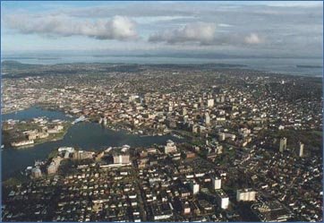
Victoria on Vancouver Island


Panoramic Earth has now added the Victoria Map on Vancouver Island in Canada BC. Victoria is the first Canadian destination to be featured. This gentle town played an important part in the region until the arrival of the rail network, when primacy then shifted to Vancouver on the mainland. Victoria makes a good starting point for exploring Vancouver Island, filled with museums, arts and craft shops. A lot of the artwork, glasswork and sculptures available here are of a very high standard and made locally.

Unfortunately, we were unable to take an image of the Orca pods that are in the area (for obvious reasons), but there is plenty else to browse through including panoramic images of the Parliament Buildings, Beacon Hill park, the Quay and the Empress Hotel.

New Panoramas on Panoramic Earth