We are happy to announce that PanoramicEarth.com is now completely labeled with both the Internet Content Rating System (IRCA) and SafeSurf labels on all pages.
In recognition of the problems of ensuring that unwanted web content is not thrust unwittingly upon the user by website owners (whether accidentally or deliberately) we support the efforts of both the IRCA and SafeSurf to provide a means of rating web content in a responsible manner.
Naturally, these indicate that all the pages of Panoramic Earth are safe for all people of all ages.
Wednesday, March 29, 2006
Wednesday, March 22, 2006
Panoramic Earth - Some History
So, where did PanoramicEarth.com come from, where are we going, or is it all just round in circles? Well, it can certainly feel that way when taking panoramic images, as anyone who has done so for some time will be able to tell you. The whole concept of creating a library of panoramic tours from around the world started some 7 years ago in the recesses of the brain of Martin Watts, the main force behind MAI Technology.com.
A few years later, almost over the proverbial pint, this was being discussed with Peter Watts (yep, brothers), with London in mind. The challenge then was to be able to successfully accomplish a couple of things. A kind of Mission Impossible (ish). London is a big place, a busy city and very popular as a travel destination.
Challenge 1 : The Photos.
Not quite as easy as it sounds. London is big. It is busy, and people don’t tend to take the needs of anyone else, least of all someone with a tripod, into account as they rush by (well, through if you are unlucky).
After the people come the huge numbers of buses, vans and other vehicles both large and small that delight in obscuring the building of interest. It is simply not a matter of just turning up and pointing a camera. Especially when the best locations for a given shot appear to be the middle of the road.
And then you can toss in the greatest variable of all – the British Weather. As has been commented not a few times, London is not quite as sunny as would be indicated by the current tour. No, indeed. But endless grey clouds and raindrops an appealing picture make, do not.
Challenge 2 : The Usage
Having battled through the former, finally rising tired from looking at pixels, the second challenge has been to get it ‘out there’. How do you, on what was then a non-existent budget, promote the tour effectively and will people really want to see it. Well, more on that later, but we have managed to get to the point where a search for ‘London Map’ on Google, MSN and others, will show the-london-map.co.uk among the first page of returns. The golden page. On a shoe string. With hours of slog. Well, maybe the domain name helped a bit ;)
This gives us confidence that what we have managed to do for London, we will be able to do for the other locations we cover in the future. After that came Hawaii Island, two weeks of running around, all those fantastic beaches and no time to swim (except twice at the end of long days).
And where will we go from here? Well, look out for Paris, New York, Rome, Barcelona and others which all feature in our plans for 2006.
Monday, March 20, 2006
Panoramic Earth goes to Oxford

There are few places in England with the reputation of Oxford, so it was only fitting that PanoramicEarth.com created a tour of this famous city. The whole area is steeped in history, and with the city centre so well preserved it feels like a step back in time. Naturally most people come here to have a look at the University buildings, and try to understand how University life here runs. It is notable however, that the bigger and more famous the college, the more they will charge to allow you to take a peek inside their sacrosanct quads and chapels.
The colleges are so old that most of the lawns here have been manicured since before the USA existed as either a British colony or an independent nation. It is home to a number of famous writers including the author of Lord of the Rings
Oxford is also know as the town of dreaming spires. We have managed to get skyline shots from four different lookout points, including Carfax Tower and the spire of the University Church of St. Mary the Virgin, which looks out onto the Radcliffe Camera and grounds of All Souls College (though this took over 30 minutes of waiting for a squall to pass and is not one likely to be repeated quickly).
Other sights to look out for on this tour include Magdalen Bridge, which becomes the focus for the May Morning celebrations, where students, often still inebriated from the previous night, will scale any barriers the authorities may dare to erect and hurl themselves into the shallow waters of the River Cherwell. Every year there is the inevitable tally of sprained and broken limbs, but this barely seems to dent the enthusiasm of the jumpers at all.
PanoramicEarth.com would like to thank the Oxford Daily Info for permission to use their map as the basis for this tour.
Wednesday, March 15, 2006
Panoramic Earth meets Stumbleupon.com
 Every once in a while an event catches your eye, and causes you to look a little further. This was our experience recently with Stumbleupon.com. Suddenly, like an exploding supernova lighting up the night sky, the referrals from this site flashed upon our web logs. It has been interesting watching the development and demise of this traffic source over the recent weeks. There are always a few sources of traffic that you get used to seeing. A couple of our regulars for us include both Flybirdy.com and Britainexpress.com, both of which regularly shine in our traffic sky, and both were equally eclipsed by Stumbleupon in recent days. Yet as Stumbleupon fades away in the traffic skies, both Flybirdy and Britainexpress grow brighter and brighter.
Sadly, like all supernovae, this brightening of our web life seems to have vanished as quickly as it came, leaving only an afterglow in our memories as we wonder where these inter-site travellers have gone to next. All that we can say is that we wish you well in your travels, thank you for coming by in such numbers. Maybe one day another new cluster of Stumbleupon members will burst upon our horizons again. At that point we at PanoramicEarth.com will have to change our analogy here from a supernova to a commet. Until then...
So, so long and thanks for all the clicks.
And may all your browsers always paginate.
Monday, March 06, 2006
Tagzania
Our Tagzania experiment:
Tagzania, a site that allows users to put points onto a Google Map location database and then add a comment and reference tags to it. Anyone who has used del.icio.us will be used to tags for web pages. These act as your own labels for your stored information. However, these tags effectively form part of a searchable database of information that allows other users to find your entries.
As an experiment, Panoramic Earth entered map points for the images we have taken in London. A sample of a Tagzania map is shown above. Each of the markers will give a little more information about the location itself. This has been useful as we have been able to collect the geomaping data on the way through, which will hopefully be used in a future development of the Panoramic Earth site.
More Panoramic Earth Tagzania locations.
Wednesday, March 01, 2006
Jungfrau Ski Region 2006
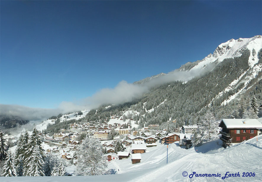
In January Panoramic Earth undertook a project in the Jungfrau region of Switzerland to construct an interactive tour of the area. This was challenging for a number of reasons, not least because of the need to carry around camera equipment while skiing, the potential effects of cold on the equipment and the rapid changes in weather conditions that can occur on the mountains. This resulting tour covers most of the skiing area around Grindelwald, Lauterbrunnen, Mürren and Wengen. This includes Kleine Scheidegg, Mürren-Schilthorn and Männlichen skiing sections of the Jungfrau. There are about 70 panoramic images which give a good impression of the slopes and surrounding mountains. The North Face of the Eiger and the peak of Jungfraujoch features prominently in many of them.
Special features of this tour include:
- The starting point of the Men’s World Cup 2006 Final shot during the race on the last day.
- Views from the platform behind the Piz Gloria restaurant, situated at the top of the Schilthorn and the set for Blofeld’s lair in the 1969 James Bond film On Her Majesty`s Secret Service.
- Views covering the villages of Lauterbrunnen, Murren and Wengen.
- Spectacular views from the tops of the Männlichen, Lauberhorn and Schilthorn mountains
- Views of both the start and finish points of the infamous Inferno Race.
Subscribe to:
Posts (Atom)