Showing posts with label bridge. Show all posts

Saturday, December 09, 2006

Southwark Bridge - London

Southwark Bridge across the River Thames in London

This photo of the view of Southwark Bridge London is part of one of the panoramic images found on the PanoramicEarth.com Tour of London. There are over 100 images taken from around London linked to an interactive map.

Plan your visit to London by taking advantage of these London Hotel Specials or Thomson City Breaks. Get the most of London with these London Guide Books

Southwark Bridge spans the River Thames in London linking the City of London with Southwark. The next bridge downstream is London Bridge (often confused with Tower Bridge), while upstream is the Millennium Bridge (for pedestrians only) and then Balckfriars Bridge.

There are many important sites close to Southwark Bridge, especially along the southern bank of the Thames. Proceed upriver and you will quickly pass the Rose Theatre Exhibition, the Globe Theatre and then the Tate Modern. Travel in the other direction and you will find the Clink Prison Museum, Golden Hind replica boat and then Southwark Cathedral. St. Paul’s Cathedral is not too far away on the northern side of the river. It is easy to spend most of the day here, and some of the attractions are free with the London Pass.

The first bridge crossing the Thames at this point was not built until 1819. It was an iron bridge designed by John Rennie (who also designed the Serpentine Bridge in Hyde Park), and featured in Charles Dickens' Little Dorrit.

The current Southwark Bridge opened in 1921 and is now maintained by the Bridge House Estates, which is a charitable trust overseen by the Corporation of London. Southwark Bridge is often used as a coach park at the weekends, and it can be hard to find a place to look up or down the Thames given the number of coaches that can be parked here.

Over 200 Destinations with HotelConnect.

The nearest tube stations include Mansion House, London Bridge and Cannon Street.

The full panoramic image taken from the junction of Southwark Bridge can be found on the London tour by PanoramicEarth.com. An enlargement of this photo can be found on Flickr. You can also find a marker for Southwark Bridge on Tagzania.

For more articles on London see the London Index or select one of the labels at the bottom.

Serpentine Bridge - London

Serpentine Bridge in Kensington Gardens and Hyde Park

This photo of the view of the Serpentine Bridge London is part of one of the panoramic images found on the PanoramicEarth.com Tour of London. There are over 100 images taken from around London linked to an interactive map.

Plan your visit to London by taking advantage of these London Hotel Specials or Thomson City Breaks. Get the most of London with these London Guide Books

The Serpentine Bridge spans the Serpentine in Hyde Park at the north end of Exhibition Road. This road then becomes West Carriage Way, which continues north and separates Hyde Park from Kensington Gardens. From the Serpentine Bridge you get a great view down the Serpentine east, towards the West End of London.

The Serpentine is a man made lake covering some 40 acres, created by Queen Caroline in the 1730 by damning Westbourne Stream. Unlike other man made lakes of the period, the Serpentine was given a natural curve, a design that was quickly copied in most other grand gardens of the time. The Queen also took about 300 acres of Hyde Park and to make Kensington Gardens to go with Kensington Palace. Hyde Park was then separated from Kensington Gardens by a ha-ha.

Like the rest of the parkland, the lake here officially divides into two. The area towards the West End is the Serpentine (situated in Hyde Park), while the lake on the other side of the bridge is called Long Water and lies in Kensington Gardens. The Italian Gardens are at the far end of Long Water and there is also a statue of Peter Pan. The first wife of Percy Shelley, a famous 19C writer, drowned herself in the Serpentine in 1818. Percy later married Mary, who wrote Frankenstein.

The bridge itself is more recent and dates from around the 1820s by John Rennie when King George IV was renovating the park. Near to the bridge you will find the Serpentine Gallery, Diana Memorial Fountain and the Albert Memorial.

If you follow Exhibition Road south out of the park then you will be taken towards South Kensington and the Museum district where you will find the Victoria and Albert, Science and Natural History Museums (along with the Earth Galleries).

Over 200 Destinations with HotelConnect.

The nearest tube station is Hyde Park Corner, while South Kensington is about 10 minutes away down Exhibition Road.

The full panoramic image taken from the junction of the Serpentine Bridge can be found on the London tour by PanoramicEarth.com. An enlargement of this photo can be found on Flickr. You can also find a marker for Serpentine Bridge in Hyde Park on Tagzania.

For more articles on London see the London Index or select one of the labels at the bottom.

Tuesday, December 05, 2006

Lambeth Bridge - London

View of Palace of Westminster and London Eye from Lambeth Bridge

This photo of the view of Lambeth Bridge in London is part of one of the panoramic images found on the PanoramicEarth.com Tour of London. There are over 100 images taken from around London linked to an interactive map.

Plan your visit to London by taking advantage of these London Hotel Specials or Thomson City Breaks. Get the most of London with these London Guide Books

There has been a Thames crossing at the current site of Lambeth Bridge for centuries, though the first bridge crossing here was built in 1862. The original Lambeth Bridge was a toll suspension bridge, but the approaches were too steep for most coaches to use. The current bridge was built in 1932 by King George V. At either end are Obelisks topped with pine cones – the traditional symbol of hospitality since Roman times.

Lambeth Bridge links Westminster with Lambeth and offers great views back up the Thames towards Westminster Bridge. Just on the south side of Lambeth Bridge is the Museum of Garden History and Lambeth Palace, the London residence of the Archbishop of Canterbury. There is a peasant walk along the Thames opposite the Houses of Parliament from Lambeth Bridge to Westminster Bridge.

On the north side, Lambeth Bridge joins up to Horseferry Road and Millbank. Here also is the southern end of Victoria Tower Gardens, which link the bridge with the Palace of Westminster. These gardens contain a number of statues, including a suffragette and a cast of Rodin's Burghers of Calais.

As can be seen from this photo, looking down the river towards Westminster from Lambeth Bridge you get a great view of the Palace of Westminster, partially shielded by the trees of the Victoria Tower Gardens. The rest of London appears on the skyline above Westminster Bridge, while on the left the London Eye towers over the surrounding buildings.

Up until 1750 the Thames crossing here used to be by ferry, which had the unfortunate reputation for sinking. In 1633 it did so with the belongings of Archbishop Laud, and then in 1656 carrying Oliver Cromwell’s coach. Early attempts to secure permission for a bridge received successful opposition from the Company of Watermen. However, the opening of Westminster Bridge in 1750 killed off the ferry trade. Another 100 years passed before the first Lambeth Bridge was built.

Over 200 Destinations with HotelConnect.

The nearest Tube stations to Lambeth Bridge include Lambeth North and Westminster.

The full panoramic image taken Lambeth Bridge can be found on the London tour by PanoramicEarth.com. An enlargement of this photo can be found on Flickr. You can also find a marker for Lambeth Bridge on Tagzania.

For more articles on London see the London Index or select one of the labels at the bottom.

Thursday, November 30, 2006

Hungerford Bridge - London

View from Hungerford Bridge in London showing London Eye and Palace of Westminster

This photo of the view from Hungerford Bridge in London is part of one of the panoramic images found on the PanoramicEarth.com Tour of London. There are over 100 images taken from around London linked to an interactive map.

Plan your visit to London by taking advantage of these London Hotel Specials or Thomson City Breaks. Get the most of London with these London Guide Books

Hungerford bridge links Charring Cross with Waterloo railway stations across the Thames. It is a composite of three bridges, one for trains bordered on either side by passenger bridges. This combination of bridges may also be known as Charring Cross Bridge or Golden Jubilee Bridges which can get confusing at times. The construction blends in very well with the appearance of the London Eye nearby as it sits between Westminster Bridge and Waterloo Bridge.

The original Hungerford Bridge was a suspension bridge by Brunel in 1845, but this was quickly replaced around 1860 by 9 iron spans on pillars, though the original pile buttresses of the suspension bridge still remain, that on the north bank sits right by Embankment Gardens. Pedestrian walkways were added, refurbished and removed at various points over the next 150 years or so, but by the end of the 20C these had a reputation for being narrow, dilapidated and poorly lit.

The new footbridges achieved several notable things. Firstly they provided new 4.7m wide and 320m long foot-spans across the river on both sides of the railway bridge. Secondly, they brought back some of the history of the suspension bridge as the bridges decks are suspended from sets of cable rods attached to leaning steel pylons. This provides a new striking impression to the river and obscures the rail span. Lastly, they provided, under the guise of a publicly funded Golden Jubilee project, the money to refurbish the iron pillars of the bridge and set them inside concrete, thereby bailing out Railtrack which could not afford to do the required work to one of it’s bridges.

Unfortunately, when walking across Hungerford Bridge you can only see either up river or down river, as the rail bridge between the two footbridges obscures the views in the other direction. The panoramic image found on PanoramicEarth is a composite, taken from roughly the mid point of either span and stitched together so as to remove the central railway section.

The view from Hungerford Bridge upriver is shown here, you can see the London Eye, St. Stephens Tower (Big Ben to most) and the Palace of Westminster (Houses of Parliament). In the other direction you look downriver to Waterloo Bridge beyond which the Thames curves away to the right on the way to St. Paul’s Cathedral and the City.

Over 200 Destinations with HotelConnect.

The nearest tube stations are Waterloo, Embankment, and Charring Cross.

The full panoramic image taken from Hungerford Bridge can be found on the London tour by PanoramicEarth.com. An enlargement of this photo can be found on Flickr. You can also find a marker for Hungerford Bridge on Tagzania.

For more articles on London see the London Index or select one of the labels at the bottom.

Monday, November 27, 2006

Tower of London and Crown Jewels

Tower of London from near to Tower Bridge

This photo of The Tower of London is part of one of the panoramic images found on the PanoramicEarth.com Tour of London. There are over 100 images taken from around London linked to an interactive map.

London for Less - FREE Theatre, Dining, or Sightseeing. Get the most of London with these London Guide Books

The Tower of London is another of those London buildings that is a world famous London icon. Built on the north bank of the Thames, opposite to the GLA Headquarters and near to Tower Bridge, the Tower of London evokes visions of imprisonment and torture through the ages of British Monarchy, being a place of execution of not a few kings and queens, along with other notable traitors or prisoners. Entrance to the Tower of London and the surrounding attractions of Tower Bridge Exhibition and the HMS Belfast is free with the London Pass.

Today the Tower of London is mostly known for two things – beheadings and the Crown Jewels. It was here that Anne Boleyn was beheaded by Henry VIII in 1536, supposedly for treason, though most likely for not bearing him a son. Most executions actually occurred on Tower Hill (now the site of a tube station), and only 7 individuals, including Anne Boleyn and Lady Jane Grey, were beheaded on the Tower Green, inside the walls of the Tower of London. The tower has also been a place of plotting and murder, most notably of the 2 sons of Edward IV by Richard, who became Richard III, as written about by Shakespeare. The bones of the 2 boys were discovered many years later under the foot of a stairway.

The Tower of London has long been home to the Crown Jewels. These used to be stored in the White Tower, and were almost successfully stolen by Thomas Blood and his gang in 1671. They were foiled by the unexpected appearance of the son of the guard and the Crown Jewels were saved. For his crimes, bizarrely, Thomas Blood was awarded a £500 per year pension and access to the Royal Court. The Jewels were then moved to a purpose built storeroom, where they remained until the Great Fire in the Tower in 1841. They are now on display in a safely guarded vault.

The central part to the Tower of London is the White Tower (originally called the Great Tower) built by William the Conqueror in 1078. The Tower, constructed of imported French stone, was built to protect both London from outside invasion, and to protect the occupying Normans from London. In the 12C King Richard the Lionheart dug a moat around the Tower and also erected a surrounding wall. This moat was improved in the 13C by Henry III and remained in use until it was drained in 1830. This also finished the effective use of the Tower of London as a fortress.

The Tower of London was converted by Henry III into a royal palace adding a number of outbuildings. Although the Royal Family have not lived here since the times of Oliver Cromwell, the Tower is still guarded as a royal Palace. The Tower has in the past also served time as a zoo, with animals on site from the 13th to the 19th Centuries. The Lion Gate is almost all that remains of this use, which used to be part of the Lion Tower, and the animals moved to the new London Zoo in The Regents Park.

The Tower of London actually contains some 20 distinct towers aside from the central White Tower. These include Beauchamp Tower, Bell Tower, Bloody Tower (or the Garden Tower), Bowyer Tower, Brick Tower, Broad Arrow Tower, Byward Tower, Constable Tower, Cradle Tower, Develin Tower, Deveraux Tower, Flint Tower, Lanthorn Tower, Martin Tower, Middle Tower, St. Thomas's Tower, Salt Tower, Wakefield Tower, Wardrobe Tower and the Well Tower.

Most tourists do not venture much further east than this in London unless they are visiting Greenwich. The nearest tube station to the Tower of London is Tower Hill, which is also an entrance point to the Docklands Light Railway.

Over 200 Destinations with HotelConnect

The full panoramic image taken of the Tower of London can be found on the London tour by PanoramicEarth.com. An enlargement of this photo can be found on Flickr.

For more articles on London see the London Index or select one of the labels at the bottom.

Tuesday, November 07, 2006

Millennium Bridge in London

Millenium Bridge, view from Tate Modern with St. Paul's Cathedral in the background.

This photo of the Millennium Bridge in London is part of one of the panoramic images found on the PanoramicEarth.com Tour of London. There are over 100 images taken from around London linked to an interactive map.

Plan your visit to London by taking advantage of these London Hotel Specials or Thomson City Breaks. Get the most of London with these London Guide Books

The Millennium Bridge in London was the first bridge to be built across the Thames in London since the construction of Tower Bridge in 1894. It is a footbridge that links the Tate Modern on the south side to St. Paul’s Cathedral on the north (Free entrance with the London Pass). The Millennium Bridge opened in 2000 (hence the name) by the Queen, and then promptly shut 2 days later as the huge numbers of people crossing over it (90,000 on day one) generated a noticeable swaying motion that some found disturbing. Whilst within safety limits, it was decided to close the bridge for alterations.

Thus the Millennium Bridge (then also known as the Wobbly Bridge) remained closed for 8 months while dampeners were installed below the decks of the bridge and between the piers. Fortunately this solution has not affected the overall design and look of Millennium Bridge which forms an elegant span over the Thames.

The Millennium Bridge is 320m long structure, designed by Sir Norman Foster with sculptor Sir Anthony Caro and the engineers Arup. The concept was to create a ‘Ribbon of Steel’ or ‘Shaft of Light’ across the Thames. It is a very shallow suspension bridge with clear views along the Thames. You can stand under the Millennium Bridge on the north side and hear the impact of the footfalls being transmitted through the cables. The deck is about 4m wide and supported by 8 cables and is about 11m above the river at high tide. Millennium Bridge cost £18m to build and a further £5m to alter making the total project some £7m over budget.

Millennium Bridge is ‘Y’ shaped, the single entrance to the Bridge from St. Paul’s branches out to two platforms near to the Tate Modern. I have once noticed that in a fine drizzle a static effect built up on the bridge which resulted in fine hair gradually standing on end as people crossed over. So while the wobble may have been removed from Millennium Bridge, it may still have other surprises in store. The nature of the decking also generates it’s own hum when buggies are being pushed over.

In spite of the original problems, the Millennium Bridge is now an established and popular landmark in London. It is hard to now imagine the city without it linking two of the great attractions in the city and providing panoramic views up and down the Thames from the centre.

Nearby attractions to the Millennium Bridge include St Paul’s Cathedral, Shakespeare’s Globe Theatre, Vinolopis and The Monument (Free entrance to all these with the London Pass) among others. The nearest tube stations are St. Paul’s, Southwark, Blackfirars, Mansion House and Cannon Street.

Over 200 Destinations with HotelConnect

The full panoramic image taken from the centre of the Millennium Bridge can be found on the London tour by PanoramicEarth.com. An enlargement of this photo can be found on Flickr.

For more articles on London see the London Index or select one of the labels at the bottom.

Friday, November 03, 2006

Tower Bridge - London

Tower Bridge, view of Tower Bridge taken from City Hall at low tide.

This photo of Tower Bridge in London is part of one of the panoramic images found on the PanoramicEarth.com Tour of London. There are over 100 images taken from around London linked to an interactive map.

Plan your visit to London by taking advantage of these London Hotel Specials or Thomson City Breaks. Get the most of London with these London Guide Books

Tower Bridge is one of the most famous, and most photographed landmarks in London. Just pick up almost any book or brochure and there it is. Tower Bridge is truly iconic as it crosses the Thames next to the Tower of London. As well as being a functioning bridge, Tower Bridge also contains an exhibition about the history of the bridge, and allows you access to the high walkway that spans the two towers, giving a remarkable view of London from the top of Tower Bridge. Access to this attraction is free with the London Pass.

Tower Bridge is often confused with London Bridge, the next bridge up the Thames from Tower Bridge on the way to Westminster. Yet both the construction and function of Tower Bridge are unique for the bridges in London, with two Gothic towers and a raisable span.

But why a raisable platform? Well, in the late 1800’s London still had a functioning port at the Pool of London, which is located between London Bridge and Tower Bridge. However, the demands of commerce and traffic necessitated another bridge across the Thames. After 50 proposed designs and 8 years of planning Joseph Bazalgette's design for a bascule bridge was accepted in 1874. The central 61m (200 foot) span between the two towers was split into two bascules which can be raised to 83° to allow river traffic to pass.

Tower Bridge was steam powered, using steam engines to pump water into the accumulators and the hydraulic raising mechanism. All the machinery for this was housed in the two towers of the bridge. Being built in the Victorian era, naturally elegance and style was demanded to cover the machinery and thus we have the icon of Tower Bridge given to London. In fact the original design gave a medieval form, but was replaced with the current Victorian Gothic form.

When you stand at the centre point of Tower Bridge, where the two bascules meet, give thought to the following: It took 432 workers over 8 years to build the bridge. In so doing they used some 70,000 tons of concrete for the river bed supports, and 11,000 tones of steel in the two towers and the walkways situated near the tops of them. All this infrastructure was then clad in a mixture of Cornish granite and Portland Stone to provide the spectacle we have today. Each bascule weighed over 1000 tons, was counterbalanced within the towers and could be raised to the full height within a minute.

Other attractions near to Tower Bridge HMS Belfast, include The Monument, Winston Churchill’s Britain at War, Vinopolis, Southwark Cathedral and Tower of London. Entrance to all of these London attractions is free to holders of the London Pass. Other nearby attractions include The London Dungeon, City Hall, Hay’s Galleria (for shopping) and the Design Museum. The nearest tube station to Tower Bridge is Tower Hill, next to the Tower of London.

Over 200 Destinations with HotelConnect

The full panoramic image taken from Tower Bridge can be found on the London tour by PanoramicEarth.com. An enlargement of this photo can be found on Flickr.

For more articles on London see the London Index or select one of the labels at the bottom.

Wednesday, October 25, 2006

Blackfriars Bridge - London

Blackfriars Bridge across the River Thames in London. View up the River.

This photo from the Blackfriars Bridge in London is part of one of the panoramic images found on the PanoramicEarth.com Tour of London. There are over 100 images taken from around London linked to an interactive map.

Plan your visit to London by taking advatage of these London Hotel Specials or Thomson City Breaks.

Blackfriars Bridge is busy, some 54,000 vehicles a day kind of busy. It crosses the River Thames in London linking the City of London with Southwark. Nearby on the North side are both St. Paul’s Cathedral and The Temple in the City. Landmarks on the south side include the Tate Modern, Southwark Cathedral and the Oxo Tower. The next car bridge up-river is Waterloo Bridge and down river is London Bridge (often confused with Tower Bridge).

A crossing at Blackfriars Bridge has existed since 1769, when the first, a toll bridge, was built and was originally called the William Pitt Bridge after the then Prime Minister. The current iron bridge was built in 1869 and widened in 1910 as the volume of traffic grew.

The view in this image is up the Thames facing West. The Oxo Tower is off to the right, and The Temple is off to the left. Along the North bank are several permanently moored ships that act as both restaurants and night clubs. Most pedestrians crossing the Thames are likely to head for the Millennium Bridge which links St. Paul’s to the Tate Modern just a little further down river. The nearest tube stations are Blackfriars (also a National Rail station) and Southwark.

One of the things that made Blackfriars Bridge (in)famous in recent years was the discovery of the body of Roberto Calvi, was found hanged below one of the arches in 1982. Snr Calvi was the chairman of the Banco Ambrosiano and worked closely with the Vatican, earning him the nickname ‘God’s Banker’.

The bank collapsed in one of Italy’s largest political scandals. His death was at first attributed to suicide, but is now accepted to have been murder. He escaped Italy on a false passport and turned up dead in London 8 days later with bricks and some $15,000 in cash in his pockets. Claims have been made that Calvi's death involved the Vatican Bank (Banco Ambrosiano's main shareholder), the Mafia (which may have used Banco Ambrosiano for money laundering), and the Propaganda Due or P2 masonic lodge, of which Calvi was a member.

Over 200 Destinations with HotelConnect

The full panoramic image showing of the view from Blackfriars Bridge can be found on the London tour by PanoramicEarth.com. An enlargement of this photo can be found on Flickr.

For more articles on London see the London Index or select one of the labels at the bottom.

Tuesday, October 24, 2006

The River Thames - London

View up the River Thames in London taken from Tower Bridge

This photo up the River Thames in London is part of one of the panoramic images found on the PanoramicEarth.com Tour of London. There are over 100 images taken from around London linked to an interactive map.

Plan your visit to London by taking advantage of these London Hotel Specials or Thomson City Breaks. Get the most of London with these London Guide Books

A large number of important London attractions line the Thames, mostly on the South side, starting with the London Eye, London Aquarium and Salvador Dali Exhibition by Westminster Bridge. Nearby here is also the South Bank and Royal Festival Hall. Further down the Thames you will find Oxo Tower, Hayes Galleria, HMS Belfast, Britain at War Museum, Southwark Cathedral, Tate Modern, Design Museum and Tower Bridge. Along the north bank you will find The Monument, St. Paul's and the Tower of London. Entrance to many of these London attractions is free to holders of the London Pass.

London
owes a large proportion of it’s significance to the River Thames. Flowing from Oxford to the North Sea this river was, for hundreds of year, the lifeline and trade artery of the city. From the West India Docks on the Isle of Dogs merchant shipping would disperse for the far East. The names still survive even if the port has died. Canary Warf now houses massive office blocks instead of boats, the Royal Victoria Dock lies near to the City Airport while St. Catherine’s Quay next to Tower Bridge is home to pleasure yachts instead of barges.

In the 16C and 17C traffic up the Thames was utterly controlled by the guild of watermen who tolerated no competition whatsoever and saw many a rival off down river with or without their boat. The Thames is still a busy waterway though the number of tourist cruise ships and ferries linking the various parts of the city far outnumber the barges and other working boats.

In 18C London got so cold that the Thames froze over regularly, allowing Londoners to establish the Frost Fairs, with tents, amusements and shops on the river itself. Who knows, if ocean currents such as the Gulf Stream, are adversely affected by global warming, we may see the return of such freezes in the UK.

The Thames also had the dubious honour of being the sewer of London, with raw effluent being discharged directly into the river. Things came to a head during the Big Stink when the aroma of the river was so foul as to disrupt entirely the activities of Parliament. The sittings at the House of Commons were abandoned for a time and massive sewers installed to take the refuse away from the city.

Today the river is popular with tourists, with cruises snaking past one another to and from Westminster Pier, past Tower Bridge and onto Greenwich. This image here shows the view up the Thames from Tower Bridge (often confused with London Bridge, the next bridge up river as seen in this image). On the right is the new GLA Headquarters of the Major of London and moored in the river is the HMS Belfast, a floating museum of a battle ship. Hidden behind trees to the left are the walls and battlements of the Tower of London, home to the Crown Jewels, while nearby the skyline is punctured by the towers of the City of London. One of the most notable of these is the Swiss Rhe ‘Gherkin’ building.

Over 200 Destinations with HotelConnect

The full panoramic image showing more of Tower Bridge can be found on the London tour by PanoramicEarth.com. An enlargement of this photo can be found on Flickr.

For more articles on London see the London Index or select one of the labels at the bottom.

Friday, October 06, 2006

Ponte Rotto and Ponte Palatino

Ponte Rotto and Isola Tibernia from Ponte Platino

This image from Ponte Palatino is part of one of the panoramic images found on the PanoramicEarth.com Tour of Rome. There are over 100 images taken from around Rome linked to an interactive map.

Full panorama of the Ponte Palatino

This is a very wide angle view taken from the Ponte Palatino. The dominant area in the middle of the picture is the Isola Tiberina on which you will find the church of S Bartholomeo and the Ospedale Fatebenefratelli. The island is worth a visit as it is peaceful with few cars. To the left of the island, above the weir in the Tiber, is the Ponte Cestio linking the island to Trastevere.

The remains of an ancient bridge in the right side is of archeological interest. This is the sole remaining arch of the Ponte Rotto, which was the first stone bridge to span the Tiber. Originally the Ponte Rotto was called the Pons Aemilius, the pillars of this ancient bridge date from 179 BC, while the arches connecting them date from 142 BC. It was repaired several times from the 13C onwards until the final collapse in 1598, when it became known as the Ponte Rotto.

On the other side of Ponte Palatino, but not visible here, is the mouth of the largest sewer in ancient Rome, the Cloaca Maxima.

Ponte Palatino is an iron bridge resting on 4 stone pillars built between 1886 and 1890 designed by Vescovali. The name comes from the Palatine Hill nearby to the North. The bridge itself is not at all attractive, but offers a vital traffic link for Rome. It is the best place to see the Ponte Rotto and has pleasant views up the Tiber. It one of the longest bridge in Rome, measuring 155m.

The full panoramic image showing views both up- and down-river is found on the Rome tour by PanoramicEarth.com. For better appreciation of this image go to the collection on Flickr.

For more articles on Rome see the Rome Index or select one of the labels at the bottom.

Ponte Vittorio Emanuele

Ponte Vittorio Emmanuele in Rome

This image from Ponte Vottorio Emanuele II is part of one of the panoramic images found on the PanoramicEarth.com Tour of Rome. There are over 100 images taken from around Rome linked to an interactive map.

Full 360° panorama of the Vittorio Emanuele II bridge

The Vittorio Emanuele II bridge is a modern construction and is usually full of cars. It makes for the most direct link from the centre of Rome to the Vatican effectively joining the Corso Vottorio Emanuele with the Via De Conciliazione which then leads straight up to St. Peter’s Basilica. From here you can see up the river to the Ponte S Angelo and the Castel S Angelo, which are both in the background.

The Vittorio Emanuele II bridge was designed by Ennio De Rossi and opened on 5 June 1911, taking 25 years to build. The bridge has 3 arches and is 111m long and 20m wide. An 18th century building belonged to the Hospital Saint Spirit was destroyed during construction. It is a good example of the architecture of the time having four heavy allegorical sculptures situated over the central arch and four end pillars decorated with bronze Victories. The marble sculptures represent Liberty, Oppression defeated, Unity of Italy, and Loyalty to the Constitution.

The full panoramic image showing views both up- and down-river is found on the Rome tour by PanoramicEarth.com.. For better appreciation of this image go to the collection on Flickr.

For more articles on Rome see the Rome Index or select one of the labels at the bottom.

Wednesday, September 27, 2006

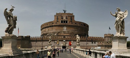
Castel Sant Angelo in Rome


The Castel Sant Angelo in Rome is one of the panoramic images found on the PanoramicEarth.com Tour of Rome. There are over 100 images taken from around Rome linked to an interactive map.

Full 360° panorama of the Castel Sant Angelo V

The Castel Sant Angelo V was originally built by the Roman Emperor Hadrian as a mausoleum for his family and known as Hadrian’s Mausoleum. It served time as a mausoleum, fort, prison, palace and now a museum. The name changed in the 6th Century when Pope Gregory the Great saw a vision of St. Michael on top of the building while praying for deliverance from a plague affecting Rome at the time. This is commemorated by a bronze statue on top the building overlooking Rome and sheathing a sword.

The first building was constructed between 135 and 139 AD. The ashes of Hadrian were buried here in 138 and succeeding emperors were buried here up to 217 AD, probably in the Treasury Room at the heart of the building.

In the 5th century the Mausoleum was converted into a fortress and incorporated into the defensive Walls built around Rome. The contents were looted by Visigoths in 410 during the sacking of Rome by Alaric.

Castel Sant Angelo and the Popes:
Pope Nicholas III connected the castle to the Vatican in the 14th century with a fortified, covered corridor called the Passetto di Borgo. During the sacking of Rome in 1527 Pope Clement VII took refuge here whilst back at the Vatican the Swiss Guard were slain to a man. Clement finally escaped dressed as a servant after several months watching Rome burn

The Castel Sant Angelo was then converted into both a papal residence, a prison and a place of torture. Paul III built a rich apartment, to make sure in a new siege the Pope had an appropriate place to stay. Leo X built a chapel decorated by Raffaello di Montelupo. Famous prisoners included Giordano Bruno, Cellini and Beatrice Cenci. Executions occurred in the small square interior of the building and skeletons excavated from the site show evidence of torture. In 1901 the building began a 30 year restoration programme and conversion to a museum.

More panoramas from Rome can be found on Panoramic Earth. For more articles on Rome see the Rome Index or select one of the labels at the bottom.

New Panoramas on Panoramic Earth