Monday, April 26, 2010

New Version of Embedded Tours

Panoramic Earth provides the opportunity to use our virtual tours as embedded content in 3rd party sites, as described on our Use a Tour page. With the launch of the new site, the style and content of these tours has been updated and the new versions are now being automatically served to our current clients.

Changing Tour Height and Width
Due to popular demand we have added the flexibility for users to alter the height of the panoramas and the maps within the tours. Within the code the following parameters can now be set:
  • width - the width of the iframe (default = 600)
  • height - the height of the iframe (default = 750 for free tours)
  • maph - height of the map within the tour (default = 200)
  • panh- height of the panorama within the tour (default = 220)
Where to put the changes
The default code supplied do not include maph and panh perameters. These must be entered after the key= parameter in the code.

Standard code:
<iframe name="panearthtour" id="panearthtour" width="600" height="750" frameborder="0" src="http://www.panoramicearth.com/tour.php?
key=nDA4ZSBP6v9xRjHkF8RU5dMIsZupIz7T391486bd2c3630f1de37e338eda7f514">This tour of Oahu requires iframes. If you cannot see the tour then please go to the <a href="http://www.panoramicearth.com/1607/United States of America/Oahu">Oahu page on Panoramic Earth</a>.</iframe>
Amended Code (changes in red):
<iframe name="panearthtour" id="panearthtour" width="600"
height="880" frameborder="0" src="http://www.panoramicearth.com/tour.php?
key=nDA4ZSBP6v9xRjHkF8RU5dMIsZupIz7T391486bd2c3630f1de37e338eda7f514
&maph=300&panh=250">This tour of Oahu requires iframes. If you cannot see the tour then please
go to the <a href="http://www.panoramicearth.com/1607/United
States of America/Oahu">Oahu page on Panoramic Earth</a>.</iframe>


Notes:
  • The height of the iframe must be adjusted accordingly.
  • Some panoramas on the sight have heights around 300 pixels high. Setting the panh parameter higher than this may result in pixilation of some images on your tour.
  • In the future we will add a simple way of doing this as you create your tour on Panoramic Earth before you are given your code.
Examples of embeded tours can be found on:

Thursday, April 22, 2010

Singapore - High Resolution Panoramas

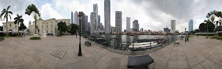
360 panorama of Singapore City from Raffles Landing SiteRaffles Landing Site, Singapore. 360 panorama (c) Peter Watts - all rights reserved

There are now over 100, high resolution, 360° virtual tour panoramas from Singapore now on Panoramic Earth. These images cover many of the sights and attractions of Singapore city and the wider island. They show various shots of the skyscrapers around Boat Bay and Clarke Quay, but also the interior of many temples and churches, some from Singapore Zoo and some of Sentosa Island.

The latest image is a hand-held panorama taken inside the shark's tunnel at the Underwater World Attraction on Setnosa Island, shown below.

360 panorama from the shark tunnel of the Underwater World in SingaporeSharks Tunnel - Underwater World, Singapore. 360 panorama (c) Peter Watts - all rights reserved

Tuesday, April 13, 2010

Panoramic Earth - New Site Launched!

Panoramic Earth (v3.0) is finally here. After months of planning and effort the new site has finally arrived. The site has many new features and a completely new look and feel, making it easier to navigate and more informative. Among the new features include:

  • Accepts Spherical as well as Cylindrical panoramas.
  • Faster loading flash panorama viewer.
  • Full screen viewing options of high resolution images.
  • Easy to follow upload interface.
  • Multi-language support.
  • Updated, faster Google maps.
  • Special Article pages.

This, however is not the end, we will continue working to add more features in the future. Please come and visit the new site, and leave feedback in the comments below. We would really like to know of development ideas you may have - you never know, we may well pick it up and add it to the next list! Happy viewing, Panoramic Earth Team

Saturday, March 06, 2010

Panoramic Earth v3.0 - Nearly There

New Panoramic Earth Homepage


As mentioned previously, Panoramic Earth is undergoing a major overhaul. We are nearly ready to launch the new version of the site - This will include several major improvements like:
  • Complete redesign of the layout and feel, with much improved functionality
  • Changes to the image uploading procedures.
  • Use of high resolution images.
  • Full screen viewing options.
  • Cylindrical (panoramas that go round and round) and Spherical (pan up and down as well) images.
  • Updating to the latest Google maps API
  • Embedding of individual images as well as regional tours
  • Better image searching, clearer tables of images.
These changes will improve the quality of work our contributors are able to display, and create a much improved experience for our visitors. Many of the basic principles will remain the same with the panoramas still linked to Google maps, and we will still intend to create a description of each one answering the 'What is it, where is it, how do I get there and what is nearby?' questions. For our contributors this means that in a short while we will be disabling new uploads to the old version during the changeover, which is expected to take a couple of days. For our visitors, it should be a fairly seamless experience, though don't be tempted to think you have come to the wrong place when it happens!

Friday, January 15, 2010

Panoramic Earth about to Change

The New Site Screenshot

Screenshot of new layout for PanoramicEarth.comFor several months now we have been working on a major site upgrade for Panoramic Earth, completely redesigning the look, feel and functionality of the site. The good news is that the principles remain the same, still showing great 360 panoramas from around the world from panoramic photographers. Still linking the images to Google maps with local and travel information.

The better news is that the site will be easier to navigate, better to look at and have much more functionality. These two screen shots show some of the differences to be expected:

The Old Site Screenshot
Screenshot of old layout for PanoramicEarth.com
  • Much cleaner feel and navigation.
  • Immediate presentation of some local information without scrolling down.
  • Thumbnails linking to nearby images.
  • Incorporation of the Krpano flash panorama viewer giving smoother action.
  • Larger, high resolution images suitable for full screen viewing.
  • Ability to display both spherical and cylindrical 360 panoramas.
  • Ability to embed single images as well as whole regional tours.
  • Local directory for each destination covered giving local travel links.
Most of the work is now completed and we expect to be able to announce a 'go live' date soon. The use of high resolution images, and incorporation of spherical panoramas, will mean some changes to the uploading and editing procedures for photographers, but this will remain a relatively simple affair.

We are very excited about these changes, offering a much better viewing experience for our visitors and expand the services we can offer the travel industry and community. 2010 will be a year of change, expansion and improvement for us.

Thursday, December 31, 2009

Growth in 2009

2009 has been an exciting time for Panoramic Earth. the number of 360 images has grown steadily over the past 12 months, as has the number of contributors to the site. Here are some of the achievements of the past year:
  • Collection grown to over 4600 panoramas from about 50 countries around the world.
  • Over 60 photographers worldwide now contribute to the site.
  • Coverage in the UK and Australia continues to grow fast.
  • Breaking ground to cover more countries, with images from India and China and USA being added.
  • Consistently ranked among the top 100,000 sites in both the UK, Australia, New Zealand and Singapore according to Alexa.
  • Introduction of the tag cloud, allowing photographers to better promote their images.
  • Nearly 200 regional tours embedded in other websites using Panoramic Earth images.
But, we will not rest there. A lot of things on the net have changed since Panoramic Earth was first launched, bringing in advances like new Flash panoramas viewers, changes to Google maps and ability to embed content in other websites. In the next year we hope to see:
  • Collection grow to about 10,000 panoramas.
  • Launch a brand new site design with more features, bells and whistles
  • Introduce new panorama viewer, allowing both spherical and high resolution images to be displayed.
  • Allow embedding of individual images into other sites
  • Simplify uploading process and access to other languages
  • Addition of forums, various article pages and photographers directory.
So, 2010 promises to be busy, full of challenges and potential. We look forward to seeing what exciting places people photograph, and wish all our members a very Happy New Year for 2010.

Monday, November 23, 2009

Panoramic Earth on TwitterCounter

TwitterCounter is yet another tool slurping data from Twitter and presenting it in visual format. In it you can see trends of how frequently different users are tweeting, who follows them and other statistics. The screenshot below shows the trending graph for Panoramic Earth on the day we signed up for the service. Interestingly, our Twitter profile showed that we had over twice as many followers and lamost 3 times as many tweets as were showing on our TwitterCounter profile. Not quite sure why that should be.

New Panoramas on Panoramic Earth